You are here: Home > Network List > TX - Texas Seismological Network Stations List
> Station SN09 Hermleigh > Earthquake Result Viewer
SN09 Hermleigh - Earthquake Result Viewer
| Earthquake location: |
Alaska Peninsula |
| Earthquake latitude/longitude: |
56.3/-156.6 |
| Earthquake time(UTC): |
2021/10/11 (284) 09:10:24 GMT |
| Earthquake Depth: |
69 km |
| Earthquake Magnitude: |
6.9 mww |
| Earthquake Catalog/Contributor: |
NEIC PDE/ak |
|
| Network: |
TX Texas Seismological Network |
| Station: |
SN09 Hermleigh |
| Lat/Lon: |
32.67 N/100.74 W |
| Elevation: |
663 m |
|
| Distance: |
44.7 deg |
| Az: |
97.628 deg |
| Baz: |
319.021 deg |
| Ray Param: |
0.07152467 |
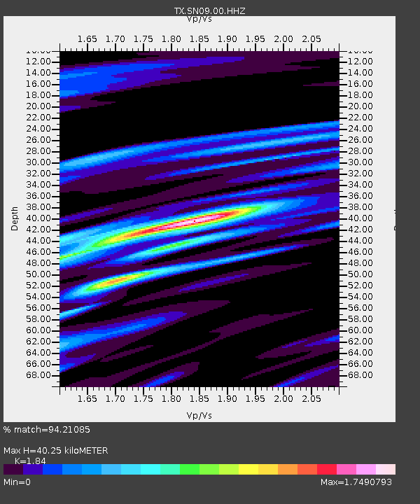
| Estimated Moho Depth: |
40.25 km |
| Estimated Crust Vp/Vs: |
1.84 |
| Assumed Crust Vp: |
6.426 km/s |
| Estimated Crust Vs: |
3.492 km/s |
| Estimated Crust Poisson's Ratio: |
0.29 |
|
| Radial Match: |
94.21085 % |
| Radial Bump: |
400 |
| Transverse Match: |
98.809875 % |
| Transverse Bump: |
175 |
| SOD ConfigId: |
26497111 |
| Insert Time: |
2021-10-25 09:36:02.351 +0000 |
| GWidth: |
2.5 |
| Max Bumps: |
400 |
| Tol: |
0.001 |
|

Signal To Noise
| Channel | StoN | STA | LTA |
| TX:SN09:00:HHZ:20211011T09:18:00.70501Z | 30.289713 | 5.6113277E-6 | 1.8525523E-7 |
| TX:SN09:00:HH1:20211011T09:18:00.70501Z | 9.13184 | 2.0070934E-6 | 2.197907E-7 |
| TX:SN09:00:HH2:20211011T09:18:00.70501Z | 21.687956 | 5.34857E-6 | 2.4661477E-7 |
| Arrivals |
| Ps | 5.6 SECOND |
| PpPs | 17 SECOND |
| PsPs/PpSs | 22 SECOND |


