You are here: Home > Network List > TX - Texas Seismological Network Stations List
> Station SN10 Rotan > Earthquake Result Viewer
SN10 Rotan - Earthquake Result Viewer
| Earthquake location: |
Alaska Peninsula |
| Earthquake latitude/longitude: |
56.3/-156.6 |
| Earthquake time(UTC): |
2021/10/11 (284) 09:10:24 GMT |
| Earthquake Depth: |
69 km |
| Earthquake Magnitude: |
6.9 mww |
| Earthquake Catalog/Contributor: |
NEIC PDE/ak |
|
| Network: |
TX Texas Seismological Network |
| Station: |
SN10 Rotan |
| Lat/Lon: |
33.05 N/100.72 W |
| Elevation: |
658 m |
|
| Distance: |
44.5 deg |
| Az: |
97.263 deg |
| Baz: |
318.769 deg |
| Ray Param: |
0.07169838 |
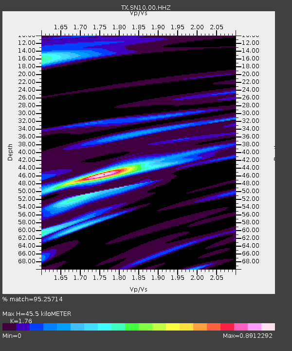
| Estimated Moho Depth: |
45.5 km |
| Estimated Crust Vp/Vs: |
1.76 |
| Assumed Crust Vp: |
6.426 km/s |
| Estimated Crust Vs: |
3.651 km/s |
| Estimated Crust Poisson's Ratio: |
0.26 |
|
| Radial Match: |
95.25714 % |
| Radial Bump: |
343 |
| Transverse Match: |
81.416016 % |
| Transverse Bump: |
400 |
| SOD ConfigId: |
26497111 |
| Insert Time: |
2021-10-25 09:36:03.008 +0000 |
| GWidth: |
2.5 |
| Max Bumps: |
400 |
| Tol: |
0.001 |
|

Signal To Noise
| Channel | StoN | STA | LTA |
| TX:SN10:00:HHZ:20211011T09:17:58.529992Z | 52.551113 | 6.736638E-6 | 1.2819211E-7 |
| TX:SN10:00:HH1:20211011T09:17:58.529992Z | 21.819633 | 3.0980475E-6 | 1.419844E-7 |
| TX:SN10:00:HH2:20211011T09:17:58.529992Z | 10.635414 | 1.9454399E-6 | 1.8292094E-7 |
| Arrivals |
| Ps | 5.7 SECOND |
| PpPs | 18 SECOND |
| PsPs/PpSs | 24 SECOND |


