You are here: Home > Network List > US - United States National Seismic Network Stations List
> Station OGNE Ogallala, Nebraska, USA > Earthquake Result Viewer
OGNE Ogallala, Nebraska, USA - Earthquake Result Viewer
| Earthquake location: |
Alaska Peninsula |
| Earthquake latitude/longitude: |
56.3/-156.6 |
| Earthquake time(UTC): |
2021/10/11 (284) 09:10:24 GMT |
| Earthquake Depth: |
69 km |
| Earthquake Magnitude: |
6.9 mww |
| Earthquake Catalog/Contributor: |
NEIC PDE/ak |
|
| Network: |
US United States National Seismic Network |
| Station: |
OGNE Ogallala, Nebraska, USA |
| Lat/Lon: |
40.95 N/102.03 W |
| Elevation: |
1054 m |
|
| Distance: |
38.1 deg |
| Az: |
90.052 deg |
| Baz: |
312.552 deg |
| Ray Param: |
0.075583376 |
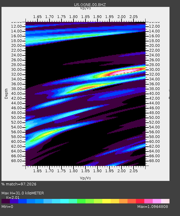
| Estimated Moho Depth: |
31.0 km |
| Estimated Crust Vp/Vs: |
2.01 |
| Assumed Crust Vp: |
6.483 km/s |
| Estimated Crust Vs: |
3.225 km/s |
| Estimated Crust Poisson's Ratio: |
0.34 |
|
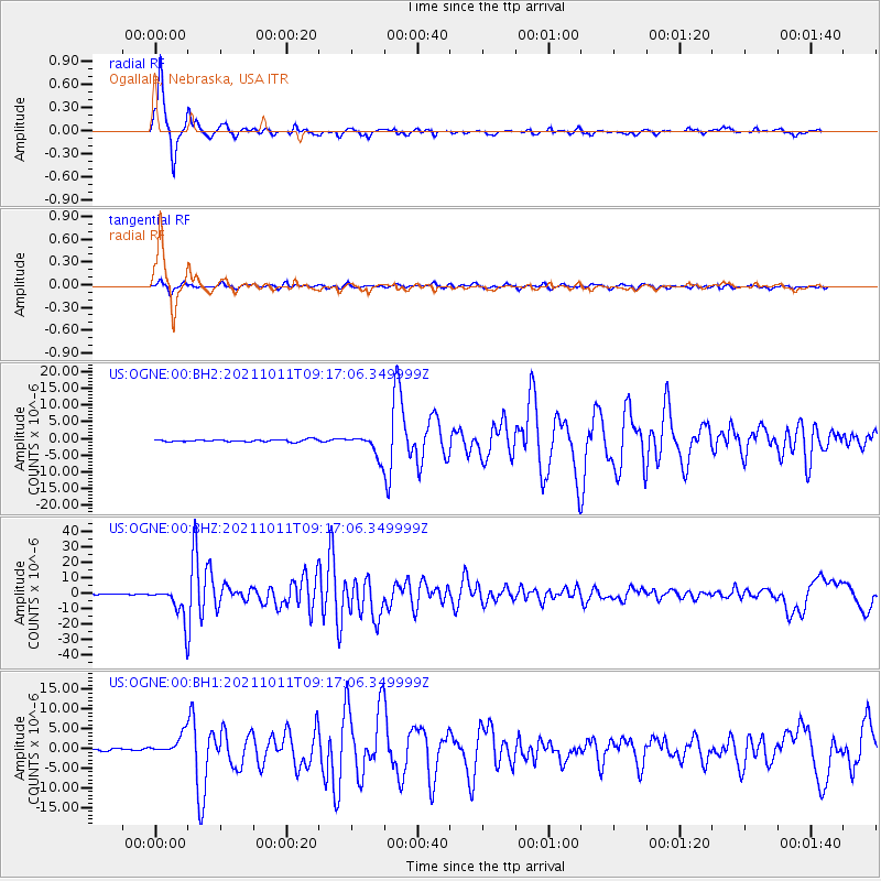
| Radial Match: |
97.2826 % |
| Radial Bump: |
226 |
| Transverse Match: |
83.17844 % |
| Transverse Bump: |
400 |
| SOD ConfigId: |
26497111 |
| Insert Time: |
2021-10-25 09:37:06.485 +0000 |
| GWidth: |
2.5 |
| Max Bumps: |
400 |
| Tol: |
0.001 |
|
Signal To Noise
| Channel | StoN | STA | LTA |
| US:OGNE:00:BHZ:20211011T09:17:06.349999Z | 73.04578 | 1.06430125E-5 | 1.4570332E-7 |
| US:OGNE:00:BH1:20211011T09:17:06.349999Z | 7.3085265 | 2.6264322E-6 | 3.593655E-7 |
| US:OGNE:00:BH2:20211011T09:17:06.349999Z | 9.94081 | 3.295137E-6 | 3.314757E-7 |
| Arrivals |
| Ps | 5.2 SECOND |
| PpPs | 13 SECOND |
| PsPs/PpSs | 19 SECOND |


