You are here: Home > Network List > UU - University of Utah Regional Network Stations List
> Station FSB3 FORGE surface borehole 3, UT, USA > Earthquake Result Viewer
FSB3 FORGE surface borehole 3, UT, USA - Earthquake Result Viewer
| Earthquake location: |
Alaska Peninsula |
| Earthquake latitude/longitude: |
56.3/-156.6 |
| Earthquake time(UTC): |
2021/10/11 (284) 09:10:24 GMT |
| Earthquake Depth: |
69 km |
| Earthquake Magnitude: |
6.9 mww |
| Earthquake Catalog/Contributor: |
NEIC PDE/ak |
|
| Network: |
UU University of Utah Regional Network |
| Station: |
FSB3 FORGE surface borehole 3, UT, USA |
| Lat/Lon: |
38.51 N/112.88 W |
| Elevation: |
1701 m |
|
| Distance: |
33.8 deg |
| Az: |
102.974 deg |
| Baz: |
316.119 deg |
| Ray Param: |
0.07788653 |
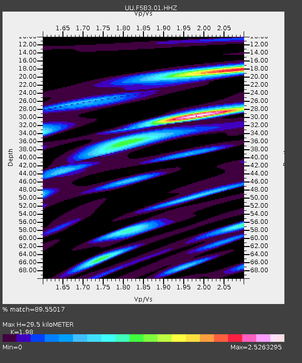
| Estimated Moho Depth: |
29.5 km |
| Estimated Crust Vp/Vs: |
1.98 |
| Assumed Crust Vp: |
6.276 km/s |
| Estimated Crust Vs: |
3.17 km/s |
| Estimated Crust Poisson's Ratio: |
0.33 |
|
| Radial Match: |
89.55017 % |
| Radial Bump: |
400 |
| Transverse Match: |
85.299225 % |
| Transverse Bump: |
400 |
| SOD ConfigId: |
26497111 |
| Insert Time: |
2021-10-25 09:37:25.749 +0000 |
| GWidth: |
2.5 |
| Max Bumps: |
400 |
| Tol: |
0.001 |
|

Signal To Noise
| Channel | StoN | STA | LTA |
| UU:FSB3:01:HHZ:20211011T09:16:29.575005Z | 12.92006 | 3.3580147E-6 | 2.5990704E-7 |
| UU:FSB3:01:HH1:20211011T09:16:29.575005Z | 3.5597339 | 1.0533415E-6 | 2.9590458E-7 |
| UU:FSB3:01:HH2:20211011T09:16:29.575005Z | 11.541004 | 2.4089586E-6 | 2.087304E-7 |
| Arrivals |
| Ps | 4.9 SECOND |
| PpPs | 13 SECOND |
| PsPs/PpSs | 18 SECOND |


