You are here: Home > Network List > UU - University of Utah Regional Network Stations List
> Station MOUT Mount Ogden, UT, USA > Earthquake Result Viewer
MOUT Mount Ogden, UT, USA - Earthquake Result Viewer
| Earthquake location: |
Alaska Peninsula |
| Earthquake latitude/longitude: |
56.3/-156.6 |
| Earthquake time(UTC): |
2021/10/11 (284) 09:10:24 GMT |
| Earthquake Depth: |
69 km |
| Earthquake Magnitude: |
6.9 mww |
| Earthquake Catalog/Contributor: |
NEIC PDE/ak |
|
| Network: |
UU University of Utah Regional Network |
| Station: |
MOUT Mount Ogden, UT, USA |
| Lat/Lon: |
41.20 N/111.88 W |
| Elevation: |
2748 m |
|
| Distance: |
32.4 deg |
| Az: |
98.484 deg |
| Baz: |
312.996 deg |
| Ray Param: |
0.07849166 |
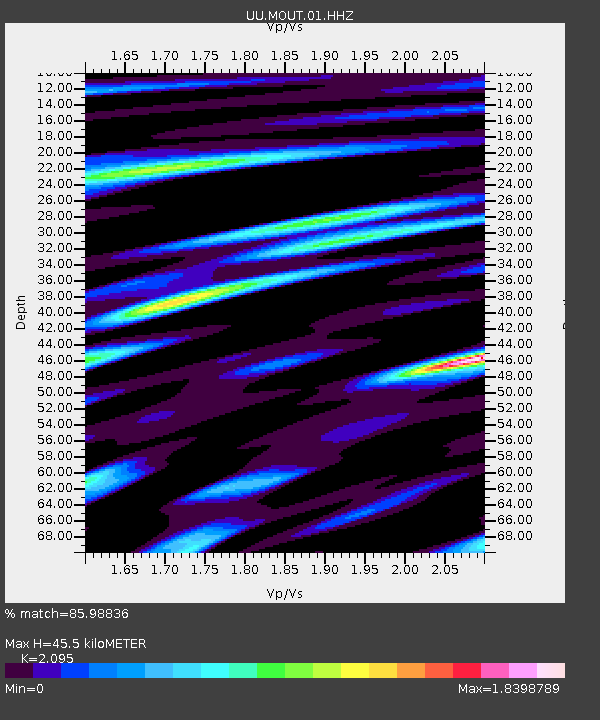
| Estimated Moho Depth: |
45.5 km |
| Estimated Crust Vp/Vs: |
2.10 |
| Assumed Crust Vp: |
6.155 km/s |
| Estimated Crust Vs: |
2.938 km/s |
| Estimated Crust Poisson's Ratio: |
0.35 |
|
| Radial Match: |
85.98836 % |
| Radial Bump: |
400 |
| Transverse Match: |
84.08677 % |
| Transverse Bump: |
400 |
| SOD ConfigId: |
26497111 |
| Insert Time: |
2021-10-25 09:37:31.558 +0000 |
| GWidth: |
2.5 |
| Max Bumps: |
400 |
| Tol: |
0.001 |
|

Signal To Noise
| Channel | StoN | STA | LTA |
| UU:MOUT:01:HHZ:20211011T09:16:17.990014Z | 24.888721 | 3.4463412E-6 | 1.3846999E-7 |
| UU:MOUT:01:HHN:20211011T09:16:17.990014Z | 8.2738905 | 1.3124875E-6 | 1.5863003E-7 |
| UU:MOUT:01:HHE:20211011T09:16:17.990014Z | 11.937819 | 1.7888162E-6 | 1.4984448E-7 |
| Arrivals |
| Ps | 8.6 SECOND |
| PpPs | 22 SECOND |
| PsPs/PpSs | 30 SECOND |


