You are here: Home > Network List > WU - The Southern Ontario Seismic Network Stations List
> Station DELO Deloro Mine, Ontario, Canada > Earthquake Result Viewer
DELO Deloro Mine, Ontario, Canada - Earthquake Result Viewer
| Earthquake location: |
Alaska Peninsula |
| Earthquake latitude/longitude: |
56.3/-156.6 |
| Earthquake time(UTC): |
2021/10/11 (284) 09:10:24 GMT |
| Earthquake Depth: |
69 km |
| Earthquake Magnitude: |
6.9 mww |
| Earthquake Catalog/Contributor: |
NEIC PDE/ak |
|
| Network: |
WU The Southern Ontario Seismic Network |
| Station: |
DELO Deloro Mine, Ontario, Canada |
| Lat/Lon: |
44.52 N/77.62 W |
| Elevation: |
213 m |
|
| Distance: |
49.0 deg |
| Az: |
68.541 deg |
| Baz: |
313.45 deg |
| Ray Param: |
0.06880759 |
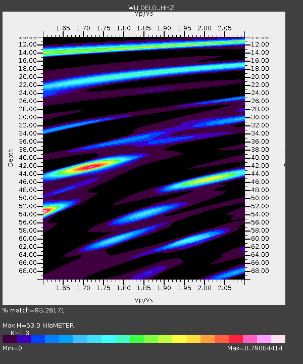
| Estimated Moho Depth: |
53.0 km |
| Estimated Crust Vp/Vs: |
1.60 |
| Assumed Crust Vp: |
6.577 km/s |
| Estimated Crust Vs: |
4.111 km/s |
| Estimated Crust Poisson's Ratio: |
0.18 |
|
| Radial Match: |
93.26171 % |
| Radial Bump: |
222 |
| Transverse Match: |
80.49153 % |
| Transverse Bump: |
400 |
| SOD ConfigId: |
26497111 |
| Insert Time: |
2021-10-25 09:38:03.328 +0000 |
| GWidth: |
2.5 |
| Max Bumps: |
400 |
| Tol: |
0.001 |
|

Signal To Noise
| Channel | StoN | STA | LTA |
| WU:DELO: :HHZ:20211011T09:18:33.635003Z | 33.631752 | 5.830053E-6 | 1.7334968E-7 |
| WU:DELO: :HHN:20211011T09:18:33.635003Z | 16.73869 | 2.0898751E-6 | 1.2485297E-7 |
| WU:DELO: :HHE:20211011T09:18:33.635003Z | 17.205318 | 2.3087136E-6 | 1.3418605E-7 |
| Arrivals |
| Ps | 5.2 SECOND |
| PpPs | 20 SECOND |
| PsPs/PpSs | 25 SECOND |


