You are here: Home > Network List > WU - The Southern Ontario Seismic Network Stations List
> Station PEMO Pembroke, Ontario, Canada > Earthquake Result Viewer
PEMO Pembroke, Ontario, Canada - Earthquake Result Viewer
| Earthquake location: |
Alaska Peninsula |
| Earthquake latitude/longitude: |
56.3/-156.6 |
| Earthquake time(UTC): |
2021/10/11 (284) 09:10:24 GMT |
| Earthquake Depth: |
69 km |
| Earthquake Magnitude: |
6.9 mww |
| Earthquake Catalog/Contributor: |
NEIC PDE/ak |
|
| Network: |
WU The Southern Ontario Seismic Network |
| Station: |
PEMO Pembroke, Ontario, Canada |
| Lat/Lon: |
45.68 N/77.25 W |
| Elevation: |
180 m |
|
| Distance: |
48.4 deg |
| Az: |
67.174 deg |
| Baz: |
312.81 deg |
| Ray Param: |
0.06920226 |
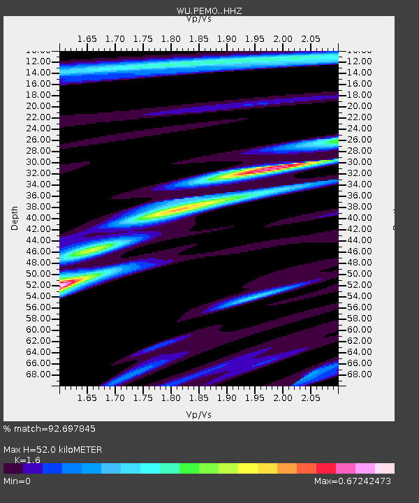
| Estimated Moho Depth: |
52.0 km |
| Estimated Crust Vp/Vs: |
1.60 |
| Assumed Crust Vp: |
6.577 km/s |
| Estimated Crust Vs: |
4.111 km/s |
| Estimated Crust Poisson's Ratio: |
0.18 |
|
| Radial Match: |
92.697845 % |
| Radial Bump: |
187 |
| Transverse Match: |
74.26701 % |
| Transverse Bump: |
400 |
| SOD ConfigId: |
26497111 |
| Insert Time: |
2021-10-25 09:38:12.263 +0000 |
| GWidth: |
2.5 |
| Max Bumps: |
400 |
| Tol: |
0.001 |
|

Signal To Noise
| Channel | StoN | STA | LTA |
| WU:PEMO: :HHZ:20211011T09:18:29.040002Z | 30.966955 | 5.2444752E-6 | 1.6935715E-7 |
| WU:PEMO: :HHN:20211011T09:18:29.040002Z | 23.224318 | 2.0481561E-6 | 8.8190156E-8 |
| WU:PEMO: :HHE:20211011T09:18:29.040002Z | 14.848746 | 2.201354E-6 | 1.4825183E-7 |
| Arrivals |
| Ps | 5.1 SECOND |
| PpPs | 19 SECOND |
| PsPs/PpSs | 24 SECOND |


