You are here: Home > Network List > CN - Canadian National Seismograph Network Stations List
> Station INK INUVIK, NT > Earthquake Result Viewer
INK INUVIK, NT - Earthquake Result Viewer
*The percent match for this event was below the threshold and hence no stack was calculated.
| Earthquake location: |
Northern Molucca Sea |
| Earthquake latitude/longitude: |
0.8/126.2 |
| Earthquake time(UTC): |
2021/10/11 (284) 12:34:32 GMT |
| Earthquake Depth: |
9.2 km |
| Earthquake Magnitude: |
5.7 Mww |
| Earthquake Catalog/Contributor: |
NEIC PDE/us |
|
| Network: |
CN Canadian National Seismograph Network |
| Station: |
INK INUVIK, NT |
| Lat/Lon: |
68.31 N/133.53 W |
| Elevation: |
44 m |
|
| Distance: |
93.0 deg |
| Az: |
21.49 deg |
| Baz: |
279.862 deg |
| Ray Param: |
$rayparam |
*The percent match for this event was below the threshold and hence was not used in the summary stack. |
|
| Radial Match: |
60.86989 % |
| Radial Bump: |
400 |
| Transverse Match: |
74.34579 % |
| Transverse Bump: |
400 |
| SOD ConfigId: |
26497111 |
| Insert Time: |
2021-10-25 12:38:51.603 +0000 |
| GWidth: |
2.5 |
| Max Bumps: |
400 |
| Tol: |
0.001 |
|
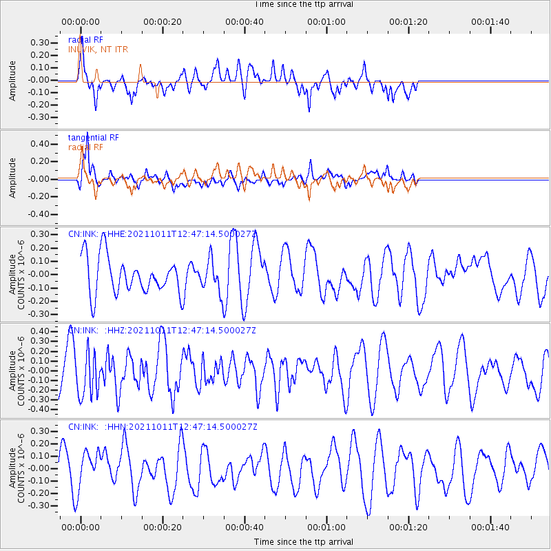
Signal To Noise
| Channel | StoN | STA | LTA |
| CN:INK: :HHZ:20211011T12:47:14.500027Z | 1.1952142 | 2.2253066E-7 | 1.8618475E-7 |
| CN:INK: :HHN:20211011T12:47:14.500027Z | 1.2477362 | 1.5062764E-7 | 1.2072074E-7 |
| CN:INK: :HHE:20211011T12:47:14.500027Z | 0.86019343 | 1.2015089E-7 | 1.3967892E-7 |
| Arrivals |
| Ps | |
| PpPs | |
| PsPs/PpSs | |


