You are here: Home > Network List > YL01 - Himalayan Nepal Tibet Experiment Stations List
> Station RUMJ YL.RUMJ > Earthquake Result Viewer
RUMJ YL.RUMJ - Earthquake Result Viewer

| Earthquake location: |
Minahassa Peninsula, Sulawesi |
| Earthquake latitude/longitude: |
-0.0/122.9 |
| Earthquake time(UTC): |
2001/12/09 (343) 18:15:02 GMT |
| Earthquake Depth: |
156 km |
| Earthquake Magnitude: |
5.7 MB, 6.2 MW, 6.0 MW |
| Earthquake Catalog/Contributor: |
WHDF/NEIC |
|
| Network: |
YL Himalayan Nepal Tibet Experiment |
| Station: |
RUMJ YL.RUMJ |
| Lat/Lon: |
27.30 N/86.55 E |
| Elevation: |
1319 m |
|
| Distance: |
44.2 deg |
| Az: |
310.884 deg |
| Baz: |
121.828 deg |
| Ray Param: |
0.071494244 |
| Estimated Moho Depth: |
13.75 km |
| Estimated Crust Vp/Vs: |
2.07 |
| Assumed Crust Vp: |
6.236 km/s |
| Estimated Crust Vs: |
3.02 km/s |
| Estimated Crust Poisson's Ratio: |
0.35 |
|
| Radial Match: |
84.98344 % |
| Radial Bump: |
400 |
| Transverse Match: |
82.93806 % |
| Transverse Bump: |
400 |
| SOD ConfigId: |
16820 |
| Insert Time: |
2010-02-26 16:06:28.384 +0000 |
| GWidth: |
2.5 |
| Max Bumps: |
400 |
| Tol: |
0.001 |
|
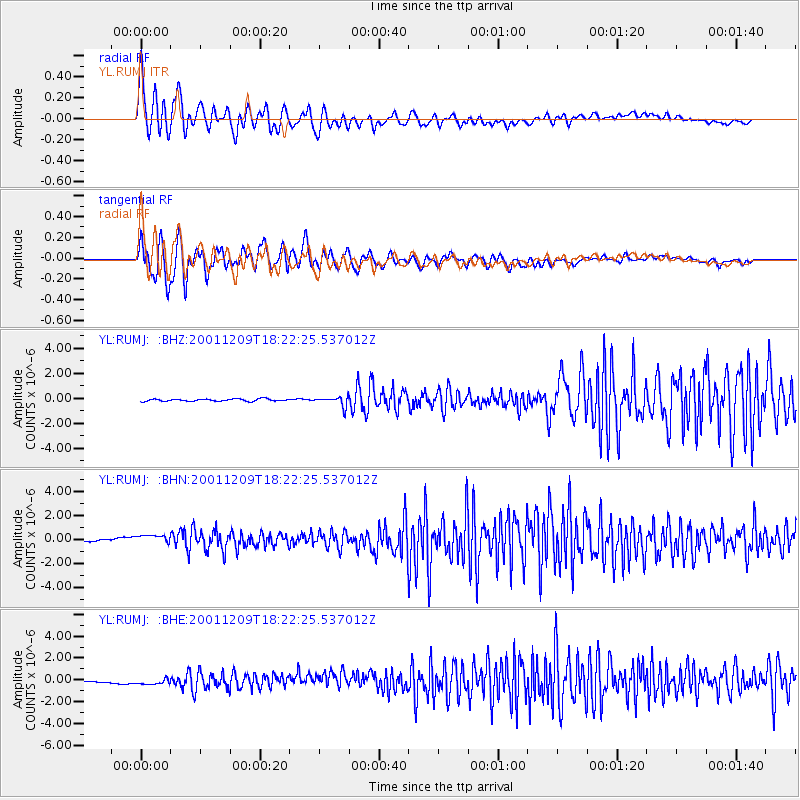
Signal To Noise
| Channel | StoN | STA | LTA |
| YL:RUMJ: :BHN:20011209T18:22:25.537012Z | 4.145917 | 4.626964E-7 | 1.116029E-7 |
| YL:RUMJ: :BHE:20011209T18:22:25.537012Z | 2.422555 | 3.881479E-7 | 1.6022254E-7 |
| YL:RUMJ: :BHZ:20011209T18:22:25.537012Z | 4.1562834 | 3.8039047E-7 | 9.152179E-8 |
| Arrivals |
| Ps | 2.5 SECOND |
| PpPs | 6.4 SECOND |
| PsPs/PpSs | 8.9 SECOND |


