You are here: Home > Network List > AZ - ANZA Regional Network Stations List
> Station SMER AZ.SMER > Earthquake Result Viewer
SMER AZ.SMER - Earthquake Result Viewer
*The percent match for this event was below the threshold and hence no stack was calculated.
| Earthquake location: |
Kuril Islands |
| Earthquake latitude/longitude: |
48.3/153.7 |
| Earthquake time(UTC): |
2021/10/11 (284) 23:10:00 GMT |
| Earthquake Depth: |
70 km |
| Earthquake Magnitude: |
5.8 Mww |
| Earthquake Catalog/Contributor: |
NEIC PDE/us |
|
| Network: |
AZ ANZA Regional Network |
| Station: |
SMER AZ.SMER |
| Lat/Lon: |
33.46 N/117.17 W |
| Elevation: |
355 m |
|
| Distance: |
65.3 deg |
| Az: |
66.906 deg |
| Baz: |
312.716 deg |
| Ray Param: |
$rayparam |
*The percent match for this event was below the threshold and hence was not used in the summary stack. |
|
| Radial Match: |
35.09422 % |
| Radial Bump: |
400 |
| Transverse Match: |
23.275614 % |
| Transverse Bump: |
400 |
| SOD ConfigId: |
26497111 |
| Insert Time: |
2021-10-25 23:15:40.539 +0000 |
| GWidth: |
2.5 |
| Max Bumps: |
400 |
| Tol: |
0.001 |
|
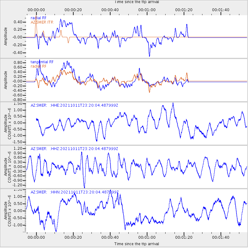
Signal To Noise
| Channel | StoN | STA | LTA |
| AZ:SMER: :HHZ:20211011T23:20:04.487999Z | 2.0984592 | 5.440215E-7 | 2.5924805E-7 |
| AZ:SMER: :HHN:20211011T23:20:04.487999Z | 0.7739615 | 4.8216725E-7 | 6.2298614E-7 |
| AZ:SMER: :HHE:20211011T23:20:04.487999Z | 1.6299057 | 5.4978136E-7 | 3.3730868E-7 |
| Arrivals |
| Ps | |
| PpPs | |
| PsPs/PpSs | |


