You are here: Home > Network List > G - GEOSCOPE Stations List
> Station PPTF Pamatai - Papeete - Tahiti island - French Polynesia, France > Earthquake Result Viewer
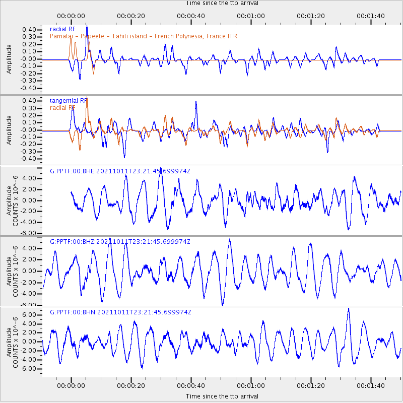
PPTF Pamatai - Papeete - Tahiti island - French Polynesia, France - Earthquake Result Viewer
*The percent match for this event was below the threshold and hence no stack was calculated.
| Earthquake location: |
Kuril Islands |
| Earthquake latitude/longitude: |
48.3/153.7 |
| Earthquake time(UTC): |
2021/10/11 (284) 23:10:00 GMT |
| Earthquake Depth: |
70 km |
| Earthquake Magnitude: |
5.8 Mww |
| Earthquake Catalog/Contributor: |
NEIC PDE/us |
|
| Network: |
G GEOSCOPE |
| Station: |
PPTF Pamatai - Papeete - Tahiti island - French Polynesia, France |
| Lat/Lon: |
17.59 S/149.57 W |
| Elevation: |
705 m |
|
| Distance: |
82.7 deg |
| Az: |
126.533 deg |
| Baz: |
325.77 deg |
| Ray Param: |
$rayparam |
*The percent match for this event was below the threshold and hence was not used in the summary stack. |
|
| Radial Match: |
60.11999 % |
| Radial Bump: |
400 |
| Transverse Match: |
77.817184 % |
| Transverse Bump: |
400 |
| SOD ConfigId: |
26497111 |
| Insert Time: |
2021-10-25 23:21:03.762 +0000 |
| GWidth: |
2.5 |
| Max Bumps: |
400 |
| Tol: |
0.001 |
|
Signal To Noise
| Channel | StoN | STA | LTA |
| G:PPTF:00:BHZ:20211011T23:21:45.699974Z | 0.7880348 | 2.1021874E-6 | 2.6676328E-6 |
| G:PPTF:00:BHN:20211011T23:21:45.699974Z | 1.0993189 | 1.7262115E-6 | 1.5702556E-6 |
| G:PPTF:00:BHE:20211011T23:21:45.699974Z | 1.7294836 | 3.5069625E-6 | 2.0277512E-6 |
| Arrivals |
| Ps | |
| PpPs | |
| PsPs/PpSs | |


