You are here: Home > Network List > GS - US Geological Survey Networks Stations List
> Station OK051 E0350 and S34600 roads, Ralston OK > Earthquake Result Viewer
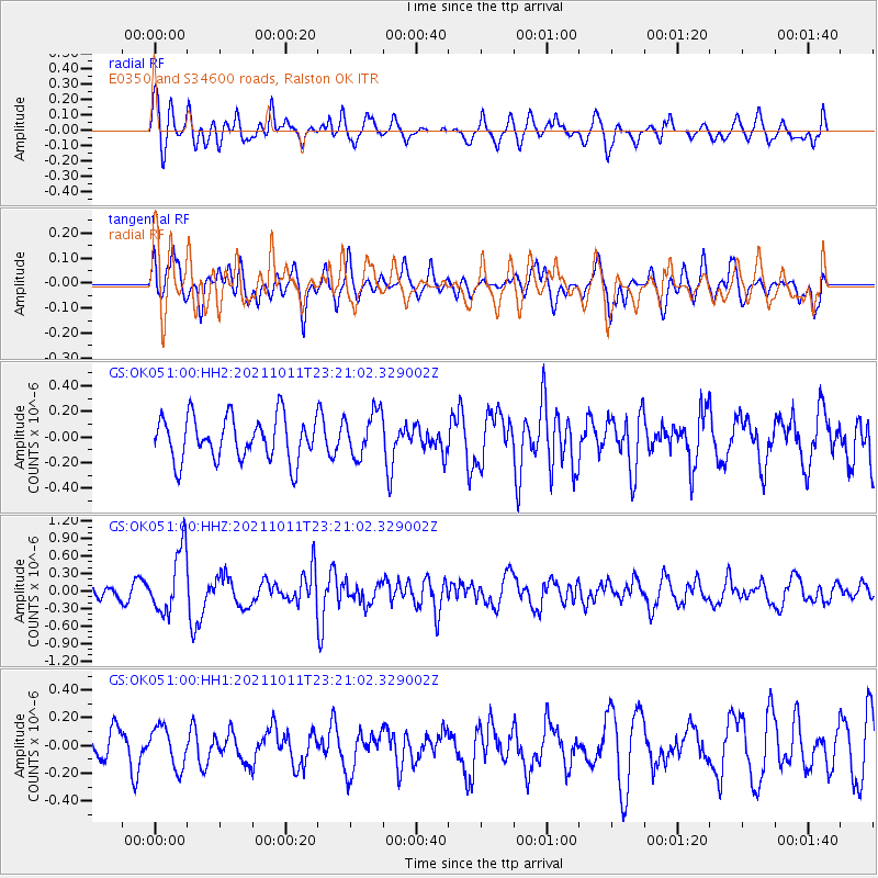
OK051 E0350 and S34600 roads, Ralston OK - Earthquake Result Viewer
*The percent match for this event was below the threshold and hence no stack was calculated.
| Earthquake location: |
Kuril Islands |
| Earthquake latitude/longitude: |
48.3/153.7 |
| Earthquake time(UTC): |
2021/10/11 (284) 23:10:00 GMT |
| Earthquake Depth: |
70 km |
| Earthquake Magnitude: |
5.8 Mww |
| Earthquake Catalog/Contributor: |
NEIC PDE/us |
|
| Network: |
GS US Geological Survey Networks |
| Station: |
OK051 E0350 and S34600 roads, Ralston OK |
| Lat/Lon: |
36.50 N/96.84 W |
| Elevation: |
263 m |
|
| Distance: |
74.8 deg |
| Az: |
51.944 deg |
| Baz: |
319.264 deg |
| Ray Param: |
$rayparam |
*The percent match for this event was below the threshold and hence was not used in the summary stack. |
|
| Radial Match: |
67.264984 % |
| Radial Bump: |
400 |
| Transverse Match: |
55.33898 % |
| Transverse Bump: |
400 |
| SOD ConfigId: |
26497111 |
| Insert Time: |
2021-10-25 23:22:23.840 +0000 |
| GWidth: |
2.5 |
| Max Bumps: |
400 |
| Tol: |
0.001 |
|
Signal To Noise
| Channel | StoN | STA | LTA |
| GS:OK051:00:HHZ:20211011T23:21:02.329002Z | 4.3433 | 5.387443E-7 | 1.2404031E-7 |
| GS:OK051:00:HH1:20211011T23:21:02.329002Z | 1.396251 | 1.452094E-7 | 1.039995E-7 |
| GS:OK051:00:HH2:20211011T23:21:02.329002Z | 1.0468078 | 1.7701802E-7 | 1.691027E-7 |
| Arrivals |
| Ps | |
| PpPs | |
| PsPs/PpSs | |


