You are here: Home > Network List > GS - US Geological Survey Networks Stations List
> Station KAN13 Rinehart Farm > Earthquake Result Viewer
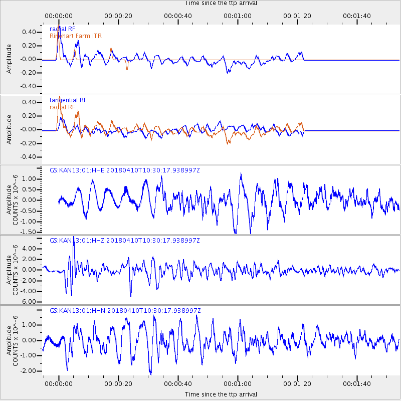
KAN13 Rinehart Farm - Earthquake Result Viewer
*The percent match for this event was below the threshold and hence no stack was calculated.
| Earthquake location: |
Near Coast Of Central Chile |
| Earthquake latitude/longitude: |
-31.0/-71.6 |
| Earthquake time(UTC): |
2018/04/10 (100) 10:19:34 GMT |
| Earthquake Depth: |
76 km |
| Earthquake Magnitude: |
6.2 Mww |
| Earthquake Catalog/Contributor: |
NEIC PDE/us |
|
| Network: |
GS US Geological Survey Networks |
| Station: |
KAN13 Rinehart Farm |
| Lat/Lon: |
37.01 N/97.48 W |
| Elevation: |
340 m |
|
| Distance: |
71.9 deg |
| Az: |
338.397 deg |
| Baz: |
156.732 deg |
| Ray Param: |
$rayparam |
*The percent match for this event was below the threshold and hence was not used in the summary stack. |
|
| Radial Match: |
71.61696 % |
| Radial Bump: |
400 |
| Transverse Match: |
39.745983 % |
| Transverse Bump: |
400 |
| SOD ConfigId: |
2653092 |
| Insert Time: |
2018-04-24 10:22:31.834 +0000 |
| GWidth: |
2.5 |
| Max Bumps: |
400 |
| Tol: |
0.001 |
|
Signal To Noise
| Channel | StoN | STA | LTA |
| GS:KAN13:01:HHZ:20180410T10:30:17.938997Z | 2.9502683 | 1.912207E-6 | 6.481468E-7 |
| GS:KAN13:01:HHN:20180410T10:30:17.938997Z | 1.0708804 | 7.3484694E-7 | 6.8620824E-7 |
| GS:KAN13:01:HHE:20180410T10:30:17.938997Z | 1.704468 | 6.266802E-7 | 3.676691E-7 |
| Arrivals |
| Ps | |
| PpPs | |
| PsPs/PpSs | |


