You are here: Home > Network List > US - United States National Seismic Network Stations List
> Station ERPA Erie, Pennsylvania, USA > Earthquake Result Viewer
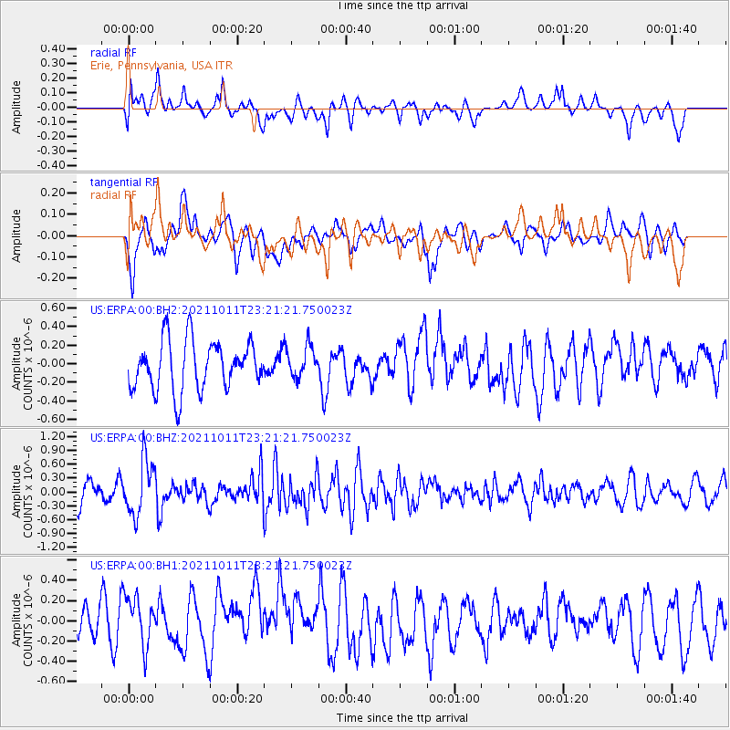
ERPA Erie, Pennsylvania, USA - Earthquake Result Viewer
*The percent match for this event was below the threshold and hence no stack was calculated.
| Earthquake location: |
Kuril Islands |
| Earthquake latitude/longitude: |
48.3/153.7 |
| Earthquake time(UTC): |
2021/10/11 (284) 23:10:00 GMT |
| Earthquake Depth: |
70 km |
| Earthquake Magnitude: |
5.8 Mww |
| Earthquake Catalog/Contributor: |
NEIC PDE/us |
|
| Network: |
US United States National Seismic Network |
| Station: |
ERPA Erie, Pennsylvania, USA |
| Lat/Lon: |
42.12 N/79.99 W |
| Elevation: |
306 m |
|
| Distance: |
78.3 deg |
| Az: |
37.787 deg |
| Baz: |
326.639 deg |
| Ray Param: |
$rayparam |
*The percent match for this event was below the threshold and hence was not used in the summary stack. |
|
| Radial Match: |
56.70811 % |
| Radial Bump: |
400 |
| Transverse Match: |
48.02579 % |
| Transverse Bump: |
400 |
| SOD ConfigId: |
26497111 |
| Insert Time: |
2021-10-25 23:33:12.279 +0000 |
| GWidth: |
2.5 |
| Max Bumps: |
400 |
| Tol: |
0.001 |
|
Signal To Noise
| Channel | StoN | STA | LTA |
| US:ERPA:00:BHZ:20211011T23:21:21.750023Z | 1.5721681 | 5.9136204E-7 | 3.7614427E-7 |
| US:ERPA:00:BH1:20211011T23:21:21.750023Z | 1.6785126 | 2.8810578E-7 | 1.7164349E-7 |
| US:ERPA:00:BH2:20211011T23:21:21.750023Z | 0.63995665 | 1.6900242E-7 | 2.6408415E-7 |
| Arrivals |
| Ps | |
| PpPs | |
| PsPs/PpSs | |


