You are here: Home > Network List > IU - Global Seismograph Network (GSN - IRIS/USGS) Stations List
> Station CCM Cathedral Cave, Missouri, USA > Earthquake Result Viewer
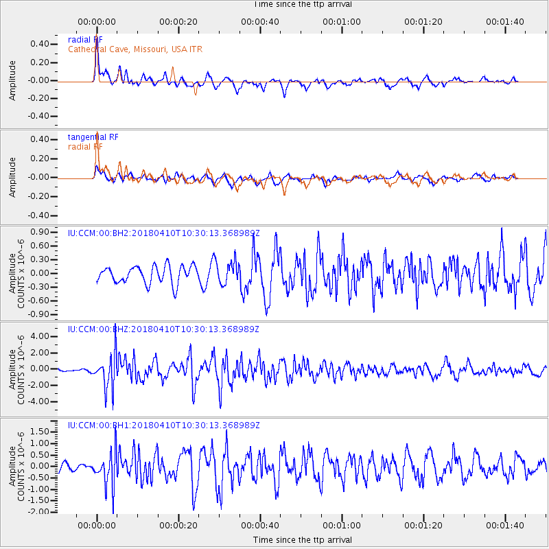
CCM Cathedral Cave, Missouri, USA - Earthquake Result Viewer
*The percent match for this event was below the threshold and hence no stack was calculated.
| Earthquake location: |
Near Coast Of Central Chile |
| Earthquake latitude/longitude: |
-31.0/-71.6 |
| Earthquake time(UTC): |
2018/04/10 (100) 10:19:34 GMT |
| Earthquake Depth: |
76 km |
| Earthquake Magnitude: |
6.2 Mww |
| Earthquake Catalog/Contributor: |
NEIC PDE/us |
|
| Network: |
IU Global Seismograph Network (GSN - IRIS/USGS) |
| Station: |
CCM Cathedral Cave, Missouri, USA |
| Lat/Lon: |
38.06 N/91.24 W |
| Elevation: |
222 m |
|
| Distance: |
71.1 deg |
| Az: |
343.674 deg |
| Baz: |
162.193 deg |
| Ray Param: |
$rayparam |
*The percent match for this event was below the threshold and hence was not used in the summary stack. |
|
| Radial Match: |
69.0072 % |
| Radial Bump: |
400 |
| Transverse Match: |
63.206596 % |
| Transverse Bump: |
400 |
| SOD ConfigId: |
2653092 |
| Insert Time: |
2018-04-24 10:23:06.735 +0000 |
| GWidth: |
2.5 |
| Max Bumps: |
400 |
| Tol: |
0.001 |
|
Signal To Noise
| Channel | StoN | STA | LTA |
| IU:CCM:00:BHZ:20180410T10:30:13.368989Z | 5.7519727 | 2.1365927E-6 | 3.714539E-7 |
| IU:CCM:00:BH1:20180410T10:30:13.368989Z | 2.4935582 | 7.52993E-7 | 3.0197532E-7 |
| IU:CCM:00:BH2:20180410T10:30:13.368989Z | 1.2987553 | 2.4114658E-7 | 1.8567515E-7 |
| Arrivals |
| Ps | |
| PpPs | |
| PsPs/PpSs | |


