You are here: Home > Network List > AK - Alaska Regional Network Stations List
> Station F21K Alatna River, AK, USA > Earthquake Result Viewer
F21K Alatna River, AK, USA - Earthquake Result Viewer
| Earthquake location: |
Crete, Greece |
| Earthquake latitude/longitude: |
35.2/26.3 |
| Earthquake time(UTC): |
2021/10/12 (285) 09:24:03 GMT |
| Earthquake Depth: |
10 km |
| Earthquake Magnitude: |
6.4 mww |
| Earthquake Catalog/Contributor: |
NEIC PDE/us |
|
| Network: |
AK Alaska Regional Network |
| Station: |
F21K Alatna River, AK, USA |
| Lat/Lon: |
67.22 N/153.48 W |
| Elevation: |
597 m |
|
| Distance: |
77.9 deg |
| Az: |
359.896 deg |
| Baz: |
0.219 deg |
| Ray Param: |
0.05001736 |
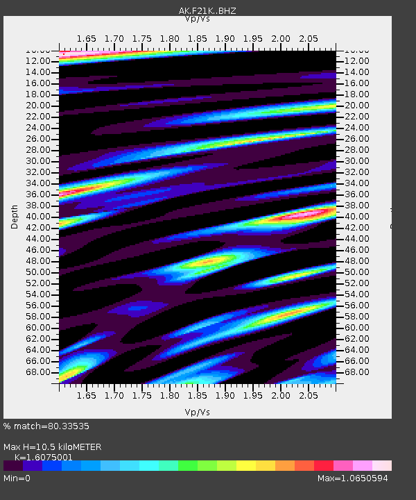
| Estimated Moho Depth: |
10.5 km |
| Estimated Crust Vp/Vs: |
1.61 |
| Assumed Crust Vp: |
6.455 km/s |
| Estimated Crust Vs: |
4.016 km/s |
| Estimated Crust Poisson's Ratio: |
0.18 |
|
| Radial Match: |
80.33535 % |
| Radial Bump: |
400 |
| Transverse Match: |
76.38624 % |
| Transverse Bump: |
400 |
| SOD ConfigId: |
26497111 |
| Insert Time: |
2021-10-26 09:26:02.009 +0000 |
| GWidth: |
2.5 |
| Max Bumps: |
400 |
| Tol: |
0.001 |
|

Signal To Noise
| Channel | StoN | STA | LTA |
| AK:F21K: :BHZ:20211012T09:35:30.399974Z | 2.5985706 | 6.3331277E-7 | 2.4371582E-7 |
| AK:F21K: :BHN:20211012T09:35:30.399974Z | 2.4647136 | 3.5033926E-7 | 1.4214199E-7 |
| AK:F21K: :BHE:20211012T09:35:30.399974Z | 1.5640161 | 2.5659264E-7 | 1.6406011E-7 |
| Arrivals |
| Ps | 1.0 SECOND |
| PpPs | 4.1 SECOND |
| PsPs/PpSs | 5.1 SECOND |


