You are here: Home > Network List > IU - Global Seismograph Network (GSN - IRIS/USGS) Stations List
> Station XMAS Kiritimati Island, Republic of Kiribati > Earthquake Result Viewer
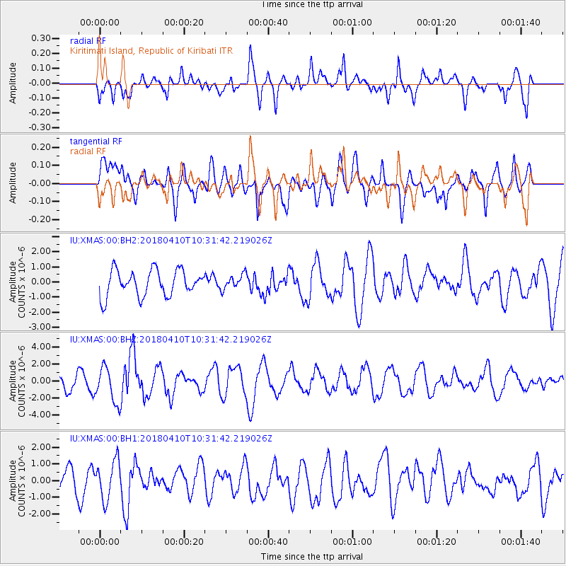
XMAS Kiritimati Island, Republic of Kiribati - Earthquake Result Viewer
*The percent match for this event was below the threshold and hence no stack was calculated.
| Earthquake location: |
Near Coast Of Central Chile |
| Earthquake latitude/longitude: |
-31.0/-71.6 |
| Earthquake time(UTC): |
2018/04/10 (100) 10:19:34 GMT |
| Earthquake Depth: |
76 km |
| Earthquake Magnitude: |
6.2 Mww |
| Earthquake Catalog/Contributor: |
NEIC PDE/us |
|
| Network: |
IU Global Seismograph Network (GSN - IRIS/USGS) |
| Station: |
XMAS Kiritimati Island, Republic of Kiribati |
| Lat/Lon: |
2.04 N/157.45 W |
| Elevation: |
20 m |
|
| Distance: |
87.5 deg |
| Az: |
273.853 deg |
| Baz: |
120.973 deg |
| Ray Param: |
$rayparam |
*The percent match for this event was below the threshold and hence was not used in the summary stack. |
|
| Radial Match: |
50.65301 % |
| Radial Bump: |
400 |
| Transverse Match: |
52.95486 % |
| Transverse Bump: |
400 |
| SOD ConfigId: |
2653092 |
| Insert Time: |
2018-04-24 10:23:28.335 +0000 |
| GWidth: |
2.5 |
| Max Bumps: |
400 |
| Tol: |
0.001 |
|
Signal To Noise
| Channel | StoN | STA | LTA |
| IU:XMAS:00:BHZ:20180410T10:31:42.219026Z | 2.0111265 | 2.0946638E-6 | 1.0415375E-6 |
| IU:XMAS:00:BH1:20180410T10:31:42.219026Z | 1.508298 | 1.1720667E-6 | 7.77079E-7 |
| IU:XMAS:00:BH2:20180410T10:31:42.219026Z | 0.5832789 | 5.0002365E-7 | 8.572634E-7 |
| Arrivals |
| Ps | |
| PpPs | |
| PsPs/PpSs | |


