You are here: Home > Network List > N4 - Central and EAstern US Network Stations List
> Station L40A Anamosa, IA, USA > Earthquake Result Viewer
L40A Anamosa, IA, USA - Earthquake Result Viewer
| Earthquake location: |
Crete, Greece |
| Earthquake latitude/longitude: |
35.2/26.3 |
| Earthquake time(UTC): |
2021/10/12 (285) 09:24:03 GMT |
| Earthquake Depth: |
10 km |
| Earthquake Magnitude: |
6.4 mww |
| Earthquake Catalog/Contributor: |
NEIC PDE/us |
|
| Network: |
N4 Central and EAstern US Network |
| Station: |
L40A Anamosa, IA, USA |
| Lat/Lon: |
42.06 N/91.22 W |
| Elevation: |
242 m |
|
| Distance: |
84.2 deg |
| Az: |
318.389 deg |
| Baz: |
46.921 deg |
| Ray Param: |
0.04567131 |
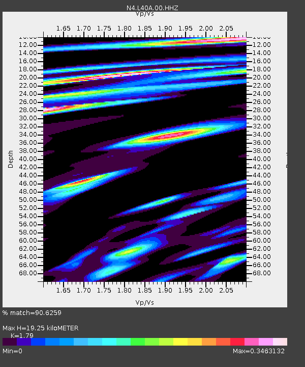
| Estimated Moho Depth: |
19.25 km |
| Estimated Crust Vp/Vs: |
1.79 |
| Assumed Crust Vp: |
6.53 km/s |
| Estimated Crust Vs: |
3.648 km/s |
| Estimated Crust Poisson's Ratio: |
0.27 |
|
| Radial Match: |
90.6259 % |
| Radial Bump: |
315 |
| Transverse Match: |
65.130356 % |
| Transverse Bump: |
400 |
| SOD ConfigId: |
26497111 |
| Insert Time: |
2021-10-26 09:35:55.399 +0000 |
| GWidth: |
2.5 |
| Max Bumps: |
400 |
| Tol: |
0.001 |
|

Signal To Noise
| Channel | StoN | STA | LTA |
| N4:L40A:00:HHZ:20211012T09:36:03.659007Z | 4.3702955 | 6.313042E-7 | 1.4445344E-7 |
| N4:L40A:00:HH1:20211012T09:36:03.659007Z | 1.452322 | 1.9764697E-7 | 1.3609032E-7 |
| N4:L40A:00:HH2:20211012T09:36:03.659007Z | 1.7486892 | 1.8977343E-7 | 1.08523246E-7 |
| Arrivals |
| Ps | 2.4 SECOND |
| PpPs | 8.0 SECOND |
| PsPs/PpSs | 10 SECOND |


