You are here: Home > Network List > NM - Cooperative New Madrid Seismic Network Stations List
> Station MGMO Mountain Grove, MO > Earthquake Result Viewer
MGMO Mountain Grove, MO - Earthquake Result Viewer
| Earthquake location: |
Crete, Greece |
| Earthquake latitude/longitude: |
35.2/26.3 |
| Earthquake time(UTC): |
2021/10/12 (285) 09:24:03 GMT |
| Earthquake Depth: |
10 km |
| Earthquake Magnitude: |
6.4 mww |
| Earthquake Catalog/Contributor: |
NEIC PDE/us |
|
| Network: |
NM Cooperative New Madrid Seismic Network |
| Station: |
MGMO Mountain Grove, MO |
| Lat/Lon: |
37.15 N/92.27 W |
| Elevation: |
453 m |
|
| Distance: |
88.1 deg |
| Az: |
315.384 deg |
| Baz: |
46.054 deg |
| Ray Param: |
0.042815115 |
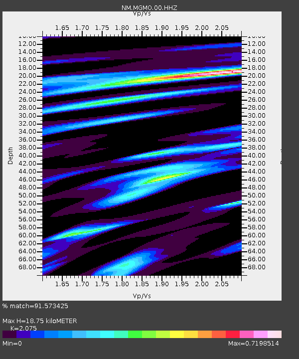
| Estimated Moho Depth: |
18.75 km |
| Estimated Crust Vp/Vs: |
2.08 |
| Assumed Crust Vp: |
6.53 km/s |
| Estimated Crust Vs: |
3.147 km/s |
| Estimated Crust Poisson's Ratio: |
0.35 |
|
| Radial Match: |
91.573425 % |
| Radial Bump: |
293 |
| Transverse Match: |
61.840515 % |
| Transverse Bump: |
400 |
| SOD ConfigId: |
26497111 |
| Insert Time: |
2021-10-26 09:37:38.655 +0000 |
| GWidth: |
2.5 |
| Max Bumps: |
400 |
| Tol: |
0.001 |
|

Signal To Noise
| Channel | StoN | STA | LTA |
| NM:MGMO:00:HHZ:20211012T09:36:23.120006Z | 2.6678846 | 3.4466925E-7 | 1.2919196E-7 |
| NM:MGMO:00:HHN:20211012T09:36:23.120006Z | 0.926799 | 1.07340966E-7 | 1.1581903E-7 |
| NM:MGMO:00:HHE:20211012T09:36:23.120006Z | 1.1840639 | 1.4880489E-7 | 1.2567303E-7 |
| Arrivals |
| Ps | 3.1 SECOND |
| PpPs | 8.7 SECOND |
| PsPs/PpSs | 12 SECOND |


