RUMJ YL.RUMJ - Earthquake Result Viewer
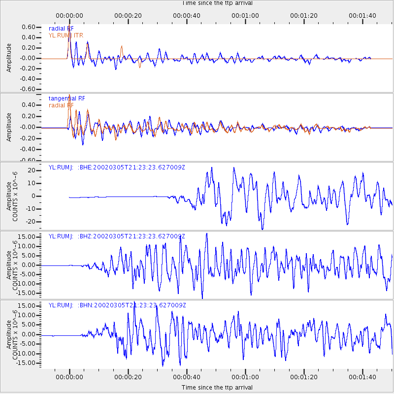
Earthquake location: Mindanao, Philippines
Earthquake latitude/longitude: 6.0/124.2
Earthquake time(UTC): 2002/03/05 (064) 21:16:09 GMT
Earthquake Depth: 31 km
Earthquake Magnitude: 6.3 MB, 7.2 MS, 7.5 MW, 7.2 MW
Earthquake Catalog/Contributor: WHDF/NEIC
Network: YL Himalayan Nepal Tibet Experiment
Station: RUMJ YL.RUMJ
Lat/Lon: 27.30 N/86.55 E
Elevation: 1319 m
Distance: 41.6 deg
Az: 304.947 deg
Baz: 113.633 deg
Ray Param: 0.07363095
Estimated Moho Depth: 14.0 km
Estimated Crust Vp/Vs: 2.03
Assumed Crust Vp: 6.236 km/s
Estimated Crust Vs: 3.072 km/s
Estimated Crust Poisson's Ratio: 0.34
Radial Match: 81.50496 %
Radial Bump: 400
Transverse Match: 81.08286 %
Transverse Bump: 400
SOD ConfigId: 16820
Insert Time: 2010-02-26 16:06:45.720 +0000
GWidth: 2.5
Max Bumps: 400
Tol: 0.001

Signal To Noise

ChannelStoNSTALTA
YL:RUMJ: :BHZ:20020305T21:23:23.627009Z2.59821372.0175491E-77.765139E-8
YL:RUMJ: :BHN:20020305T21:23:23.627009Z1.0739983.0932543E-72.8801304E-7
YL:RUMJ: :BHE:20020305T21:23:23.627009Z1.51610453.9280013E-72.5908514E-7
Arrivals
Ps2.4 SECOND
PpPs6.4 SECOND
PsPs/PpSs8.9 SECOND