You are here: Home > Network List > NM - Cooperative New Madrid Seismic Network Stations List
> Station HENM Henderson Mound,MO > Earthquake Result Viewer
HENM Henderson Mound,MO - Earthquake Result Viewer
| Earthquake location: |
Near Coast Of Central Chile |
| Earthquake latitude/longitude: |
-31.0/-71.6 |
| Earthquake time(UTC): |
2018/04/10 (100) 10:19:34 GMT |
| Earthquake Depth: |
76 km |
| Earthquake Magnitude: |
6.2 Mww |
| Earthquake Catalog/Contributor: |
NEIC PDE/us |
|
| Network: |
NM Cooperative New Madrid Seismic Network |
| Station: |
HENM Henderson Mound,MO |
| Lat/Lon: |
36.72 N/89.47 W |
| Elevation: |
88 m |
|
| Distance: |
69.4 deg |
| Az: |
344.69 deg |
| Baz: |
163.608 deg |
| Ray Param: |
0.055485163 |
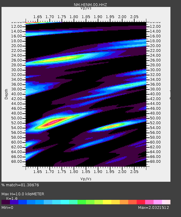
| Estimated Moho Depth: |
10.0 km |
| Estimated Crust Vp/Vs: |
1.60 |
| Assumed Crust Vp: |
6.444 km/s |
| Estimated Crust Vs: |
4.027 km/s |
| Estimated Crust Poisson's Ratio: |
0.18 |
|
| Radial Match: |
81.38676 % |
| Radial Bump: |
400 |
| Transverse Match: |
83.04846 % |
| Transverse Bump: |
400 |
| SOD ConfigId: |
2653092 |
| Insert Time: |
2018-04-24 10:24:23.971 +0000 |
| GWidth: |
2.5 |
| Max Bumps: |
400 |
| Tol: |
0.001 |
|

Signal To Noise
| Channel | StoN | STA | LTA |
| NM:HENM:00:HHZ:20180410T10:30:03.04001Z | 15.408583 | 4.691157E-6 | 3.044509E-7 |
| NM:HENM:00:HHN:20180410T10:30:03.04001Z | 2.2205408 | 1.4246738E-6 | 6.4158866E-7 |
| NM:HENM:00:HHE:20180410T10:30:03.04001Z | 1.7346218 | 1.2839972E-6 | 7.4021744E-7 |
| Arrivals |
| Ps | 1.0 SECOND |
| PpPs | 3.9 SECOND |
| PsPs/PpSs | 4.8 SECOND |


