You are here: Home > Network List > WI - West Indies IPGP Network Stations List
> Station BIM Morne Bigot, Anses d'Arlets, Martinique > Earthquake Result Viewer
BIM Morne Bigot, Anses d'Arlets, Martinique - Earthquake Result Viewer
| Earthquake location: |
Crete, Greece |
| Earthquake latitude/longitude: |
35.2/26.3 |
| Earthquake time(UTC): |
2021/10/12 (285) 09:24:03 GMT |
| Earthquake Depth: |
10 km |
| Earthquake Magnitude: |
6.4 mww |
| Earthquake Catalog/Contributor: |
NEIC PDE/us |
|
| Network: |
WI West Indies IPGP Network |
| Station: |
BIM Morne Bigot, Anses d'Arlets, Martinique |
| Lat/Lon: |
14.52 N/61.07 W |
| Elevation: |
391 m |
|
| Distance: |
79.6 deg |
| Az: |
280.429 deg |
| Baz: |
56.276 deg |
| Ray Param: |
0.048831634 |
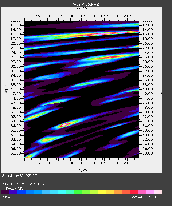
| Estimated Moho Depth: |
55.25 km |
| Estimated Crust Vp/Vs: |
1.77 |
| Assumed Crust Vp: |
5.88 km/s |
| Estimated Crust Vs: |
3.318 km/s |
| Estimated Crust Poisson's Ratio: |
0.27 |
|
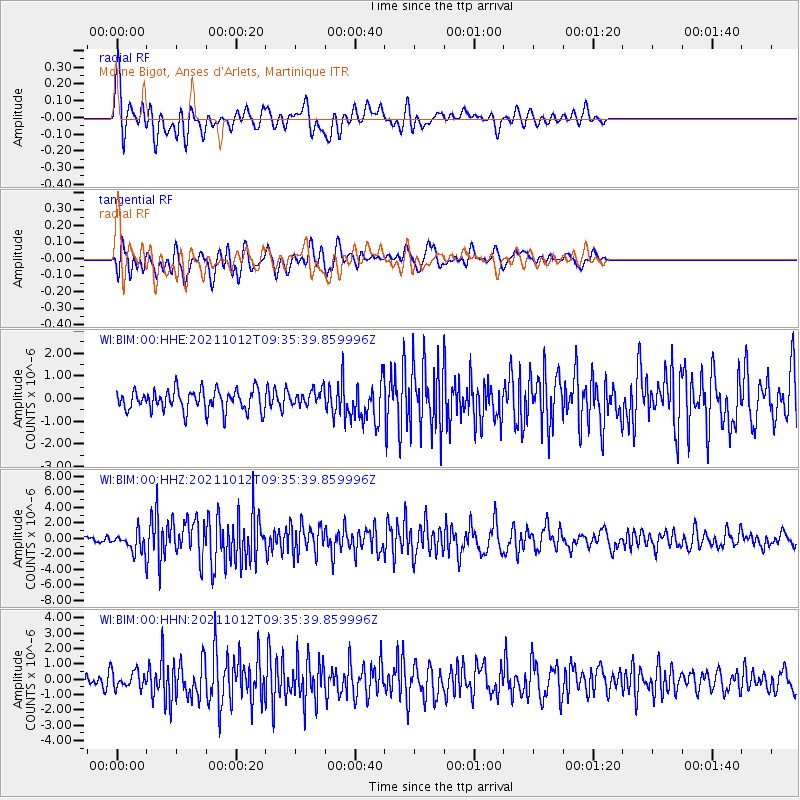
| Radial Match: |
81.02127 % |
| Radial Bump: |
400 |
| Transverse Match: |
67.298546 % |
| Transverse Bump: |
400 |
| SOD ConfigId: |
26497111 |
| Insert Time: |
2021-10-26 09:43:44.046 +0000 |
| GWidth: |
2.5 |
| Max Bumps: |
400 |
| Tol: |
0.001 |
|
Signal To Noise
| Channel | StoN | STA | LTA |
| WI:BIM:00:HHZ:20211012T09:35:39.859996Z | 3.9022365 | 1.2229784E-6 | 3.1340448E-7 |
| WI:BIM:00:HHN:20211012T09:35:39.859996Z | 1.0297908 | 5.483003E-7 | 5.3243855E-7 |
| WI:BIM:00:HHE:20211012T09:35:39.859996Z | 0.75044584 | 3.4662764E-7 | 4.6189564E-7 |
| Arrivals |
| Ps | 7.4 SECOND |
| PpPs | 25 SECOND |
| PsPs/PpSs | 33 SECOND |


