You are here: Home > Network List > YL01 - Himalayan Nepal Tibet Experiment Stations List
> Station RUMJ YL.RUMJ > Earthquake Result Viewer
RUMJ YL.RUMJ - Earthquake Result Viewer
| Earthquake location: |
Southern Greece |
| Earthquake latitude/longitude: |
36.6/24.3 |
| Earthquake time(UTC): |
2002/05/21 (141) 20:53:29 GMT |
| Earthquake Depth: |
97 km |
| Earthquake Magnitude: |
5.4 MB, 5.6 MD |
| Earthquake Catalog/Contributor: |
WHDF/NEIC |
|
| Network: |
YL Himalayan Nepal Tibet Experiment |
| Station: |
RUMJ YL.RUMJ |
| Lat/Lon: |
27.30 N/86.55 E |
| Elevation: |
1319 m |
|
| Distance: |
52.8 deg |
| Az: |
81.257 deg |
| Baz: |
296.679 deg |
| Ray Param: |
0.06619213 |
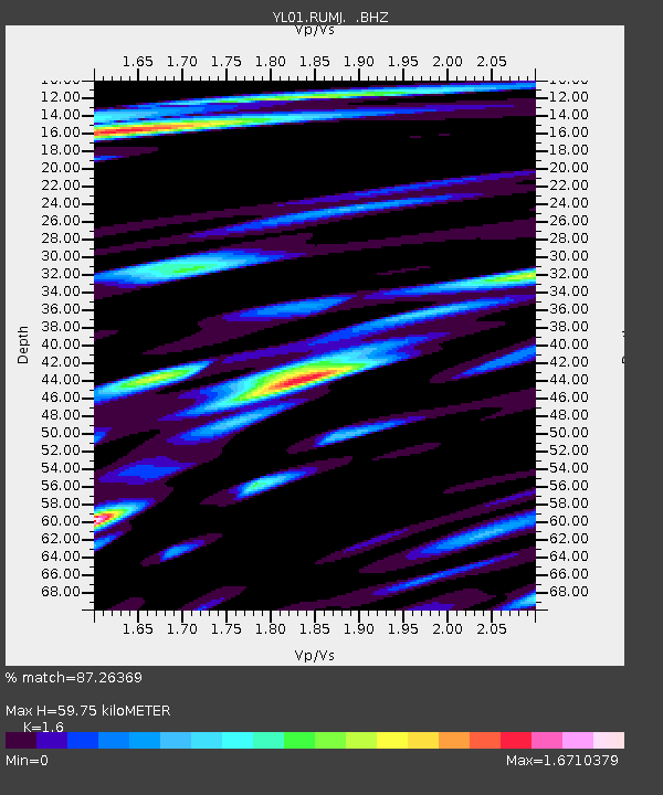
| Estimated Moho Depth: |
59.75 km |
| Estimated Crust Vp/Vs: |
1.60 |
| Assumed Crust Vp: |
6.236 km/s |
| Estimated Crust Vs: |
3.897 km/s |
| Estimated Crust Poisson's Ratio: |
0.18 |
|
| Radial Match: |
87.26369 % |
| Radial Bump: |
400 |
| Transverse Match: |
88.71164 % |
| Transverse Bump: |
400 |
| SOD ConfigId: |
16844 |
| Insert Time: |
2010-02-26 16:06:55.626 +0000 |
| GWidth: |
2.5 |
| Max Bumps: |
400 |
| Tol: |
0.001 |
|
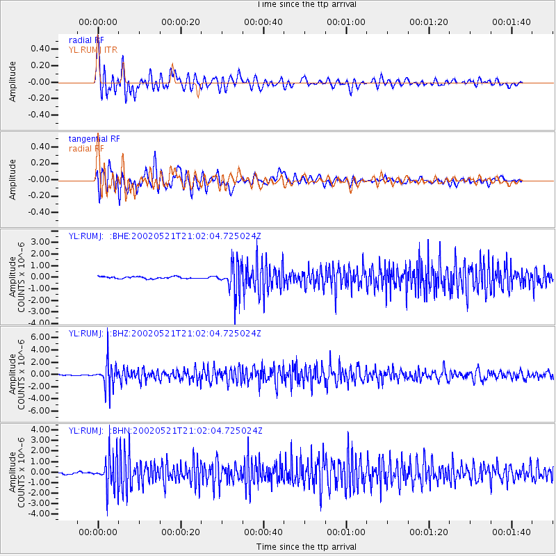
Signal To Noise
| Channel | StoN | STA | LTA |
| YL:RUMJ: :BHZ:20020521T21:02:04.725024Z | 23.77324 | 1.965334E-6 | 8.2670006E-8 |
| YL:RUMJ: :BHN:20020521T21:02:04.725024Z | 16.677479 | 1.5047243E-6 | 9.022493E-8 |
| YL:RUMJ: :BHE:20020521T21:02:04.725024Z | 15.090344 | 1.2537114E-6 | 8.308037E-8 |
| Arrivals |
| Ps | 6.1 SECOND |
| PpPs | 24 SECOND |
| PsPs/PpSs | 30 SECOND |


