You are here: Home > Network List > AV - Alaska Volcano Observatory Stations List
> Station PLBL Mt. Peulik Volcano, Alaska > Earthquake Result Viewer
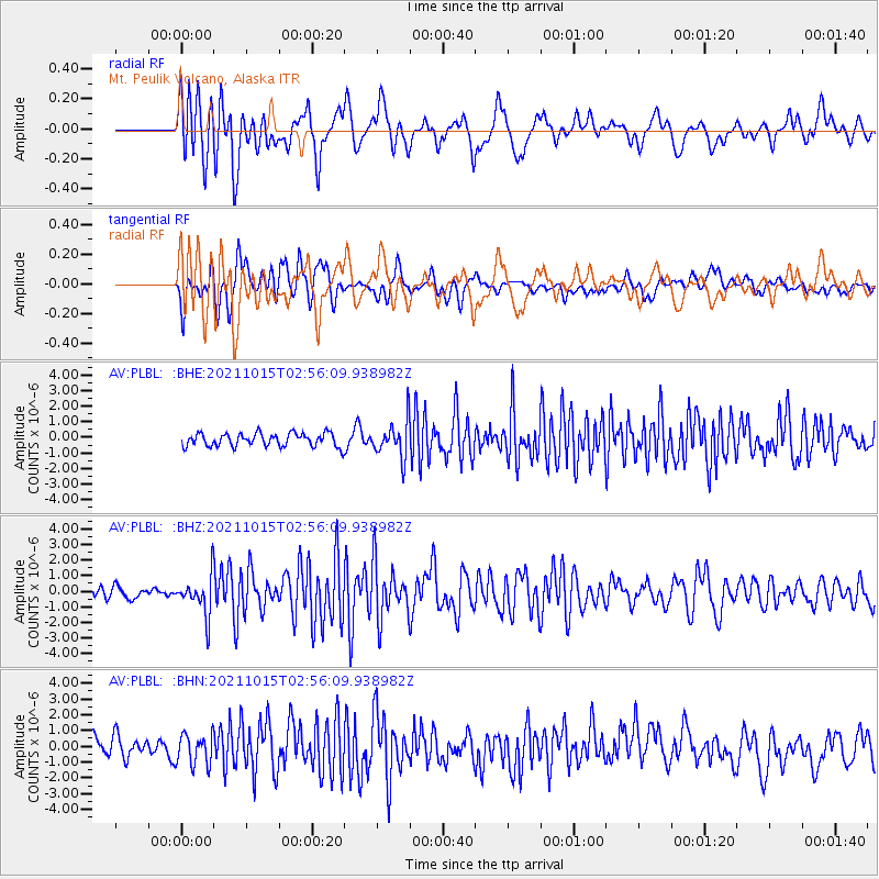
PLBL Mt. Peulik Volcano, Alaska - Earthquake Result Viewer
*The percent match for this event was below the threshold and hence no stack was calculated.
| Earthquake location: |
Solomon Islands |
| Earthquake latitude/longitude: |
-8.9/158.5 |
| Earthquake time(UTC): |
2021/10/15 (288) 02:44:57 GMT |
| Earthquake Depth: |
23 km |
| Earthquake Magnitude: |
6.4 mww |
| Earthquake Catalog/Contributor: |
NEIC PDE/us |
|
| Network: |
AV Alaska Volcano Observatory |
| Station: |
PLBL Mt. Peulik Volcano, Alaska |
| Lat/Lon: |
57.70 N/156.82 W |
| Elevation: |
461 m |
|
| Distance: |
75.7 deg |
| Az: |
22.943 deg |
| Baz: |
225.843 deg |
| Ray Param: |
$rayparam |
*The percent match for this event was below the threshold and hence was not used in the summary stack. |
|
| Radial Match: |
73.19552 % |
| Radial Bump: |
400 |
| Transverse Match: |
62.64433 % |
| Transverse Bump: |
400 |
| SOD ConfigId: |
26497111 |
| Insert Time: |
2021-10-29 02:52:39.632 +0000 |
| GWidth: |
2.5 |
| Max Bumps: |
400 |
| Tol: |
0.001 |
|
Signal To Noise
| Channel | StoN | STA | LTA |
| AV:PLBL: :BHZ:20211015T02:56:09.938982Z | 3.7974987 | 1.2677816E-6 | 3.3384651E-7 |
| AV:PLBL: :BHN:20211015T02:56:09.938982Z | 1.6131951 | 9.5312816E-7 | 5.9083254E-7 |
| AV:PLBL: :BHE:20211015T02:56:09.938982Z | 2.7711043 | 1.1825055E-6 | 4.2672713E-7 |
| Arrivals |
| Ps | |
| PpPs | |
| PsPs/PpSs | |


