You are here: Home > Network List > C8 - Canadian Seismic Research Network () Stations List
> Station GRIB Gribbell Island, BC, CA > Earthquake Result Viewer
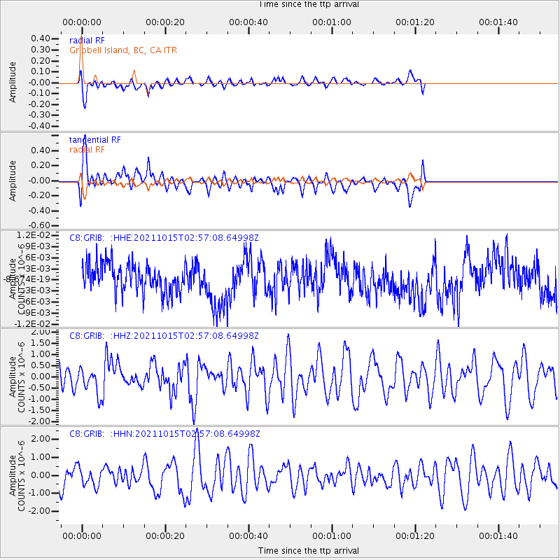
GRIB Gribbell Island, BC, CA - Earthquake Result Viewer
*The percent match for this event was below the threshold and hence no stack was calculated.
| Earthquake location: |
Solomon Islands |
| Earthquake latitude/longitude: |
-8.9/158.5 |
| Earthquake time(UTC): |
2021/10/15 (288) 02:44:57 GMT |
| Earthquake Depth: |
23 km |
| Earthquake Magnitude: |
6.4 mww |
| Earthquake Catalog/Contributor: |
NEIC PDE/us |
|
| Network: |
C8 Canadian Seismic Research Network () |
| Station: |
GRIB Gribbell Island, BC, CA |
| Lat/Lon: |
53.34 N/129.14 W |
| Elevation: |
418 m |
|
| Distance: |
86.7 deg |
| Az: |
34.922 deg |
| Baz: |
250.62 deg |
| Ray Param: |
$rayparam |
*The percent match for this event was below the threshold and hence was not used in the summary stack. |
|
| Radial Match: |
63.58916 % |
| Radial Bump: |
400 |
| Transverse Match: |
63.646095 % |
| Transverse Bump: |
400 |
| SOD ConfigId: |
26497111 |
| Insert Time: |
2021-10-29 02:54:08.779 +0000 |
| GWidth: |
2.5 |
| Max Bumps: |
400 |
| Tol: |
0.001 |
|
Signal To Noise
| Channel | StoN | STA | LTA |
| C8:GRIB: :HHZ:20211015T02:57:08.64998Z | 0.95816857 | 5.7946767E-7 | 6.0476594E-7 |
| C8:GRIB: :HHN:20211015T02:57:08.64998Z | 0.66742086 | 5.045516E-7 | 7.5597217E-7 |
| C8:GRIB: :HHE:20211015T02:57:08.64998Z | 1.8726069 | 6.998872E-9 | 3.7375023E-9 |
| Arrivals |
| Ps | |
| PpPs | |
| PsPs/PpSs | |


