You are here: Home > Network List > G - GEOSCOPE Stations List
> Station DRV Dumont d'Urville, Terre Adelie (Antartica) > Earthquake Result Viewer
DRV Dumont d'Urville, Terre Adelie (Antartica) - Earthquake Result Viewer

| Earthquake location: |
Solomon Islands |
| Earthquake latitude/longitude: |
-8.9/158.5 |
| Earthquake time(UTC): |
2021/10/15 (288) 02:44:57 GMT |
| Earthquake Depth: |
23 km |
| Earthquake Magnitude: |
6.4 mww |
| Earthquake Catalog/Contributor: |
NEIC PDE/us |
|
| Network: |
G GEOSCOPE |
| Station: |
DRV Dumont d'Urville, Terre Adelie (Antartica) |
| Lat/Lon: |
66.67 S/140.01 E |
| Elevation: |
40 m |
|
| Distance: |
59.1 deg |
| Az: |
188.461 deg |
| Baz: |
21.407 deg |
| Ray Param: |
0.062404986 |
| Estimated Moho Depth: |
17.75 km |
| Estimated Crust Vp/Vs: |
2.08 |
| Assumed Crust Vp: |
6.39 km/s |
| Estimated Crust Vs: |
3.079 km/s |
| Estimated Crust Poisson's Ratio: |
0.35 |
|
| Radial Match: |
95.29688 % |
| Radial Bump: |
396 |
| Transverse Match: |
81.98361 % |
| Transverse Bump: |
400 |
| SOD ConfigId: |
26497111 |
| Insert Time: |
2021-10-29 02:56:43.136 +0000 |
| GWidth: |
2.5 |
| Max Bumps: |
400 |
| Tol: |
0.001 |
|
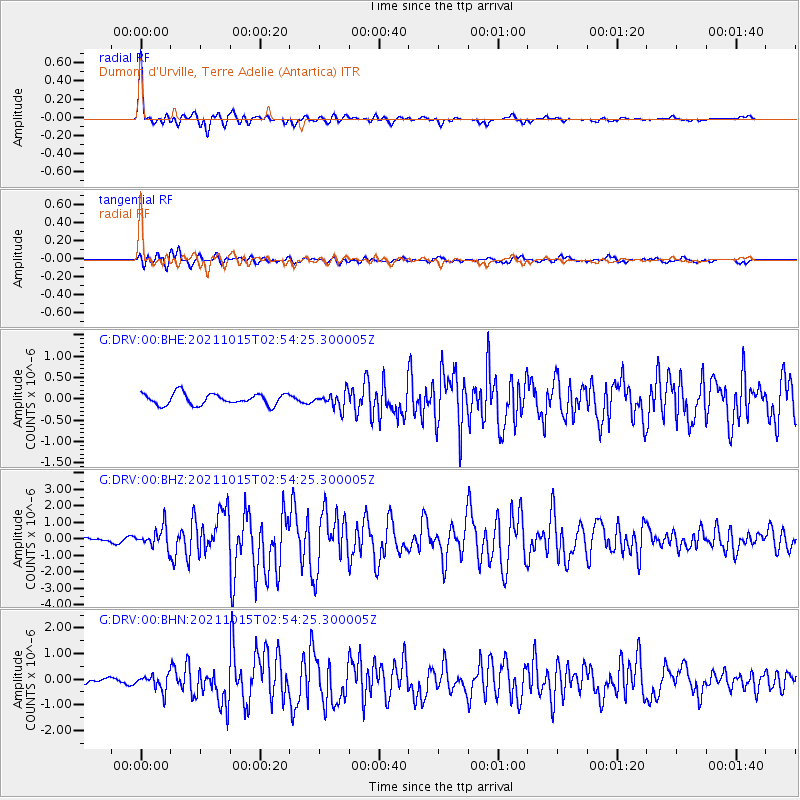
Signal To Noise
| Channel | StoN | STA | LTA |
| G:DRV:00:BHZ:20211015T02:54:25.300005Z | 4.6921563 | 6.3077795E-7 | 1.3443243E-7 |
| G:DRV:00:BHN:20211015T02:54:25.300005Z | 3.670308 | 3.1636594E-7 | 8.619602E-8 |
| G:DRV:00:BHE:20211015T02:54:25.300005Z | 1.4162732 | 1.8715107E-7 | 1.3214334E-7 |
| Arrivals |
| Ps | 3.1 SECOND |
| PpPs | 8.2 SECOND |
| PsPs/PpSs | 11 SECOND |


