You are here: Home > Network List > MM - Myanmar National Seismic Network Stations List
> Station TMU Tamu, Sagaing, Myanmar > Earthquake Result Viewer
TMU Tamu, Sagaing, Myanmar - Earthquake Result Viewer
| Earthquake location: |
Solomon Islands |
| Earthquake latitude/longitude: |
-8.9/158.5 |
| Earthquake time(UTC): |
2021/10/15 (288) 02:44:57 GMT |
| Earthquake Depth: |
23 km |
| Earthquake Magnitude: |
6.4 mww |
| Earthquake Catalog/Contributor: |
NEIC PDE/us |
|
| Network: |
MM Myanmar National Seismic Network |
| Station: |
TMU Tamu, Sagaing, Myanmar |
| Lat/Lon: |
24.23 N/94.30 E |
| Elevation: |
182 m |
|
| Distance: |
70.7 deg |
| Az: |
299.462 deg |
| Baz: |
109.534 deg |
| Ray Param: |
0.054787796 |
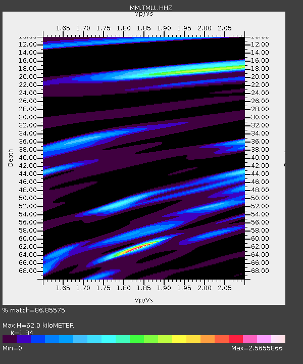
| Estimated Moho Depth: |
62.0 km |
| Estimated Crust Vp/Vs: |
1.84 |
| Assumed Crust Vp: |
6.316 km/s |
| Estimated Crust Vs: |
3.432 km/s |
| Estimated Crust Poisson's Ratio: |
0.29 |
|
| Radial Match: |
86.85575 % |
| Radial Bump: |
400 |
| Transverse Match: |
73.57936 % |
| Transverse Bump: |
400 |
| SOD ConfigId: |
26497111 |
| Insert Time: |
2021-10-29 02:58:50.999 +0000 |
| GWidth: |
2.5 |
| Max Bumps: |
400 |
| Tol: |
0.001 |
|

Signal To Noise
| Channel | StoN | STA | LTA |
| MM:TMU: :HHZ:20211015T02:55:40.83803Z | 4.9154215 | 8.412876E-7 | 1.7115269E-7 |
| MM:TMU: :HHN:20211015T02:55:40.83803Z | 2.1896968 | 3.2346887E-7 | 1.4772313E-7 |
| MM:TMU: :HHE:20211015T02:55:40.83803Z | 6.207815 | 6.1351244E-7 | 9.882905E-8 |
| Arrivals |
| Ps | 8.5 SECOND |
| PpPs | 27 SECOND |
| PsPs/PpSs | 35 SECOND |


