You are here: Home > Network List > UW - Pacific Northwest Regional Seismic Network Stations List
> Station LTY Liberty (broad-band) > Earthquake Result Viewer
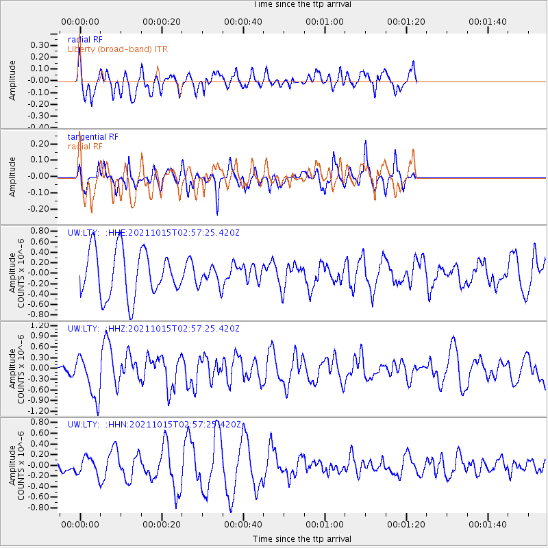
LTY Liberty (broad-band) - Earthquake Result Viewer
*The percent match for this event was below the threshold and hence no stack was calculated.
| Earthquake location: |
Solomon Islands |
| Earthquake latitude/longitude: |
-8.9/158.5 |
| Earthquake time(UTC): |
2021/10/15 (288) 02:44:57 GMT |
| Earthquake Depth: |
23 km |
| Earthquake Magnitude: |
6.4 mww |
| Earthquake Catalog/Contributor: |
NEIC PDE/us |
|
| Network: |
UW Pacific Northwest Regional Seismic Network |
| Station: |
LTY Liberty (broad-band) |
| Lat/Lon: |
47.26 N/120.66 W |
| Elevation: |
970 m |
|
| Distance: |
90.3 deg |
| Az: |
42.263 deg |
| Baz: |
257.325 deg |
| Ray Param: |
$rayparam |
*The percent match for this event was below the threshold and hence was not used in the summary stack. |
|
| Radial Match: |
62.072704 % |
| Radial Bump: |
368 |
| Transverse Match: |
66.085594 % |
| Transverse Bump: |
326 |
| SOD ConfigId: |
26497111 |
| Insert Time: |
2021-10-29 03:01:50.297 +0000 |
| GWidth: |
2.5 |
| Max Bumps: |
400 |
| Tol: |
0.001 |
|
Signal To Noise
| Channel | StoN | STA | LTA |
| UW:LTY: :HHZ:20211015T02:57:25.420Z | 2.4714887 | 6.207123E-7 | 2.5114915E-7 |
| UW:LTY: :HHN:20211015T02:57:25.420Z | 0.97027254 | 1.6367231E-7 | 1.6868694E-7 |
| UW:LTY: :HHE:20211015T02:57:25.420Z | 0.40922096 | 1.8339195E-7 | 4.4814894E-7 |
| Arrivals |
| Ps | |
| PpPs | |
| PsPs/PpSs | |


