RUMJ YL.RUMJ - Earthquake Result Viewer
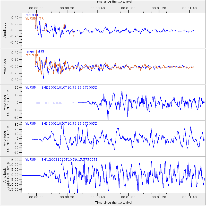
Earthquake location: Irian Jaya Region, Indonesia
Earthquake latitude/longitude: -1.8/134.3
Earthquake time(UTC): 2002/10/10 (283) 10:50:20 GMT
Earthquake Depth: 10 km
Earthquake Magnitude: 6.5 MB, 7.7 MS, 7.6 MW, 7.4 MW
Earthquake Catalog/Contributor: WHDF/NEIC
Network: YL Himalayan Nepal Tibet Experiment
Station: RUMJ YL.RUMJ
Lat/Lon: 27.30 N/86.55 E
Elevation: 1319 m
Distance: 54.3 deg
Az: 305.757 deg
Baz: 114.28 deg
Ray Param: 0.06556035
Estimated Moho Depth: 14.0 km
Estimated Crust Vp/Vs: 1.99
Assumed Crust Vp: 6.236 km/s
Estimated Crust Vs: 3.134 km/s
Estimated Crust Poisson's Ratio: 0.33
Radial Match: 89.183174 %
Radial Bump: 400
Transverse Match: 83.84361 %
Transverse Bump: 400
SOD ConfigId: 16844
Insert Time: 2010-02-26 16:07:13.384 +0000
GWidth: 2.5
Max Bumps: 400
Tol: 0.001

Signal To Noise

ChannelStoNSTALTA
YL:RUMJ: :BHZ:20021010T10:59:15.575005Z13.170792.1387864E-61.6238862E-7
YL:RUMJ: :BHN:20021010T10:59:15.575005Z7.1372817.151328E-71.0019681E-7
YL:RUMJ: :BHE:20021010T10:59:15.575005Z8.0429089.679927E-71.2035358E-7
Arrivals
Ps2.3 SECOND
PpPs6.4 SECOND
PsPs/PpSs8.7 SECOND