You are here: Home > Network List > CU - Caribbean Network (USGS) Stations List
> Station BCIP Isla Barro Colorado, Panama > Earthquake Result Viewer
BCIP Isla Barro Colorado, Panama - Earthquake Result Viewer
| Earthquake location: |
Tonga Islands Region |
| Earthquake latitude/longitude: |
-23.0/-174.7 |
| Earthquake time(UTC): |
2009/03/19 (078) 18:17:40 GMT |
| Earthquake Depth: |
34 km |
| Earthquake Magnitude: |
7.0 MB, 7.6 MS, 7.6 MW, 7.6 MW |
| Earthquake Catalog/Contributor: |
WHDF/NEIC |
|
| Network: |
CU Caribbean Network (USGS) |
| Station: |
BCIP Isla Barro Colorado, Panama |
| Lat/Lon: |
9.17 N/79.84 W |
| Elevation: |
61 m |
|
| Distance: |
97.9 deg |
| Az: |
83.421 deg |
| Baz: |
247.933 deg |
| Ray Param: |
0.040043544 |
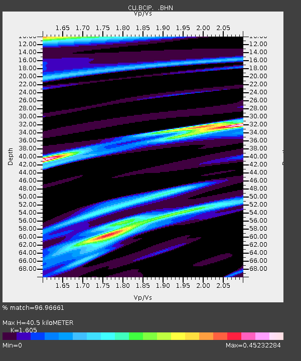
| Estimated Moho Depth: |
40.5 km |
| Estimated Crust Vp/Vs: |
1.61 |
| Assumed Crust Vp: |
6.436 km/s |
| Estimated Crust Vs: |
4.01 km/s |
| Estimated Crust Poisson's Ratio: |
0.18 |
|
| Radial Match: |
96.96661 % |
| Radial Bump: |
400 |
| Transverse Match: |
92.788055 % |
| Transverse Bump: |
400 |
| SOD ConfigId: |
2658 |
| Insert Time: |
2010-03-09 13:46:54.504 +0000 |
| GWidth: |
2.5 |
| Max Bumps: |
400 |
| Tol: |
0.001 |
|

Signal To Noise
| Channel | StoN | STA | LTA |
| CU:BCIP: :BHN:20090319T18:30:41.800015Z | 7.43063 | 1.5692907E-6 | 2.1119214E-7 |
| CU:BCIP: :BHE:20090319T18:30:41.800015Z | 0.8460202 | 4.2076226E-7 | 4.97343E-7 |
| CU:BCIP: :BHZ:20090319T18:30:41.800015Z | 1.4359646 | 4.498867E-7 | 3.132993E-7 |
| Arrivals |
| Ps | 3.9 SECOND |
| PpPs | 16 SECOND |
| PsPs/PpSs | 20 SECOND |


