You are here: Home > Network List > AU - Australian Seismological Centre Stations List
> Station KMBL Kambalda, WA > Earthquake Result Viewer
KMBL Kambalda, WA - Earthquake Result Viewer
| Earthquake location: |
Vanuatu Islands |
| Earthquake latitude/longitude: |
-13.7/166.9 |
| Earthquake time(UTC): |
2021/10/18 (291) 07:26:52 GMT |
| Earthquake Depth: |
96 km |
| Earthquake Magnitude: |
6.1 Mww |
| Earthquake Catalog/Contributor: |
NEIC PDE/us |
|
| Network: |
AU Australian Seismological Centre |
| Station: |
KMBL Kambalda, WA |
| Lat/Lon: |
31.37 S/121.88 E |
| Elevation: |
370 m |
|
| Distance: |
44.8 deg |
| Az: |
239.214 deg |
| Baz: |
77.406 deg |
| Ray Param: |
0.071362235 |
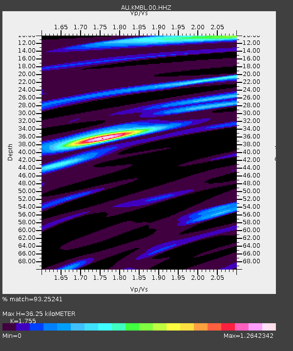
| Estimated Moho Depth: |
36.25 km |
| Estimated Crust Vp/Vs: |
1.75 |
| Assumed Crust Vp: |
6.459 km/s |
| Estimated Crust Vs: |
3.681 km/s |
| Estimated Crust Poisson's Ratio: |
0.26 |
|
| Radial Match: |
93.25241 % |
| Radial Bump: |
218 |
| Transverse Match: |
63.260174 % |
| Transverse Bump: |
400 |
| SOD ConfigId: |
26497111 |
| Insert Time: |
2021-11-01 07:31:52.647 +0000 |
| GWidth: |
2.5 |
| Max Bumps: |
400 |
| Tol: |
0.001 |
|

Signal To Noise
| Channel | StoN | STA | LTA |
| AU:KMBL:00:HHZ:20211018T07:34:26.230001Z | 12.429718 | 1.0322924E-6 | 8.3050345E-8 |
| AU:KMBL:00:HHN:20211018T07:34:26.230001Z | 3.4417777 | 1.7305427E-7 | 5.028049E-8 |
| AU:KMBL:00:HHE:20211018T07:34:26.230001Z | 8.912824 | 6.225294E-7 | 6.9846486E-8 |
| Arrivals |
| Ps | 4.5 SECOND |
| PpPs | 14 SECOND |
| PsPs/PpSs | 19 SECOND |


