You are here: Home > Network List > YL01 - Himalayan Nepal Tibet Experiment Stations List
> Station RUMJ YL.RUMJ > Earthquake Result Viewer
RUMJ YL.RUMJ - Earthquake Result Viewer

| Earthquake location: |
Near East Coast Of Kamchatka |
| Earthquake latitude/longitude: |
52.0/157.3 |
| Earthquake time(UTC): |
2002/10/16 (289) 10:12:21 GMT |
| Earthquake Depth: |
102 km |
| Earthquake Magnitude: |
6.1 MB, 6.2 MW, 6.2 MW |
| Earthquake Catalog/Contributor: |
WHDF/NEIC |
|
| Network: |
YL Himalayan Nepal Tibet Experiment |
| Station: |
RUMJ YL.RUMJ |
| Lat/Lon: |
27.30 N/86.55 E |
| Elevation: |
1319 m |
|
| Distance: |
57.3 deg |
| Az: |
273.557 deg |
| Baz: |
43.961 deg |
| Ray Param: |
0.06326077 |
| Estimated Moho Depth: |
55.75 km |
| Estimated Crust Vp/Vs: |
1.68 |
| Assumed Crust Vp: |
6.236 km/s |
| Estimated Crust Vs: |
3.717 km/s |
| Estimated Crust Poisson's Ratio: |
0.22 |
|
| Radial Match: |
89.75113 % |
| Radial Bump: |
400 |
| Transverse Match: |
89.89379 % |
| Transverse Bump: |
400 |
| SOD ConfigId: |
16844 |
| Insert Time: |
2010-02-26 16:07:17.671 +0000 |
| GWidth: |
2.5 |
| Max Bumps: |
400 |
| Tol: |
0.001 |
|
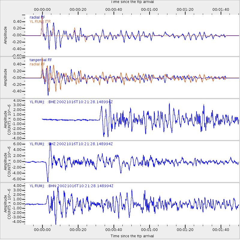
Signal To Noise
| Channel | StoN | STA | LTA |
| YL:RUMJ: :BHZ:20021016T10:21:28.148994Z | 42.49347 | 3.2589303E-6 | 7.6692494E-8 |
| YL:RUMJ: :BHN:20021016T10:21:28.148994Z | 11.874448 | 8.8341767E-7 | 7.4396524E-8 |
| YL:RUMJ: :BHE:20021016T10:21:28.148994Z | 22.286974 | 1.4661208E-6 | 6.578375E-8 |
| Arrivals |
| Ps | 6.4 SECOND |
| PpPs | 23 SECOND |
| PsPs/PpSs | 29 SECOND |


