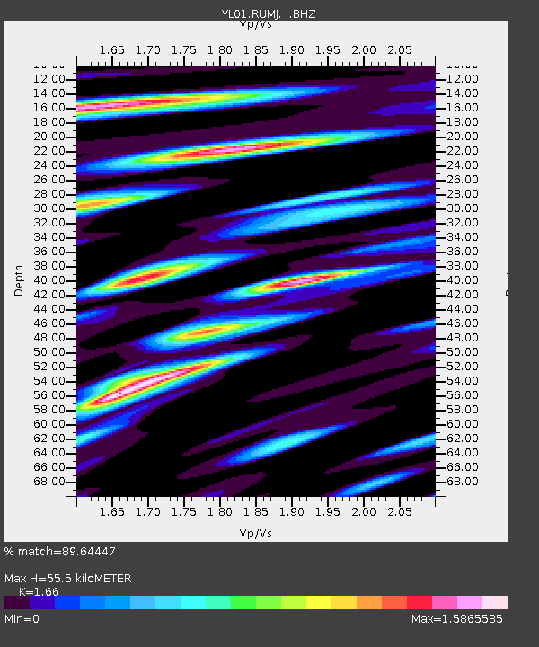
RUMJ YL.RUMJ - Earthquake Result Viewer

Earthquake location: Kuril Islands
Earthquake latitude/longitude: 44.3/150.0
Earthquake time(UTC): 2002/10/19 (292) 12:09:05 GMT
Earthquake Depth: 33 km
Earthquake Magnitude: 5.4 MB, 6.2 MS, 6.4 MW, 6.1 MW
Earthquake Catalog/Contributor: WHDF/NEIC
Network: YL Himalayan Nepal Tibet Experiment
Station: RUMJ YL.RUMJ
Lat/Lon: 27.30 N/86.55 E
Elevation: 1319 m
Distance: 52.9 deg
Az: 273.628 deg
Baz: 53.644 deg
Ray Param: 0.06641366
Estimated Moho Depth: 55.5 km
Estimated Crust Vp/Vs: 1.66
Assumed Crust Vp: 6.236 km/s
Estimated Crust Vs: 3.757 km/s
Estimated Crust Poisson's Ratio: 0.22
Radial Match: 89.64447 %
Radial Bump: 400
Transverse Match: 91.48006 %
Transverse Bump: 400
SOD ConfigId: 16844
Insert Time: 2010-02-26 16:07:19.873 +0000
GWidth: 2.5
Max Bumps: 400
Tol: 0.001

Signal To Noise

ChannelStoNSTALTA
YL:RUMJ: :BHZ:20021019T12:17:47.348994Z15.8335835.8551325E-73.6979202E-8
YL:RUMJ: :BHN:20021019T12:17:47.348994Z2.95544861.4020063E-74.7438018E-8
YL:RUMJ: :BHE:20021019T12:17:47.348994Z3.12047963.319691E-71.0638399E-7
Arrivals
Ps6.2 SECOND
PpPs22 SECOND
PsPs/PpSs29 SECOND