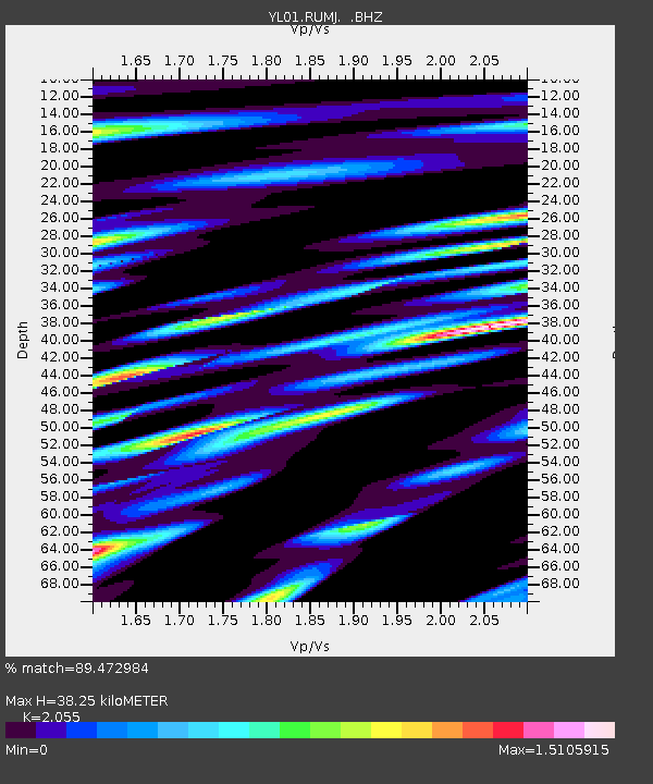
RUMJ YL.RUMJ - Earthquake Result Viewer
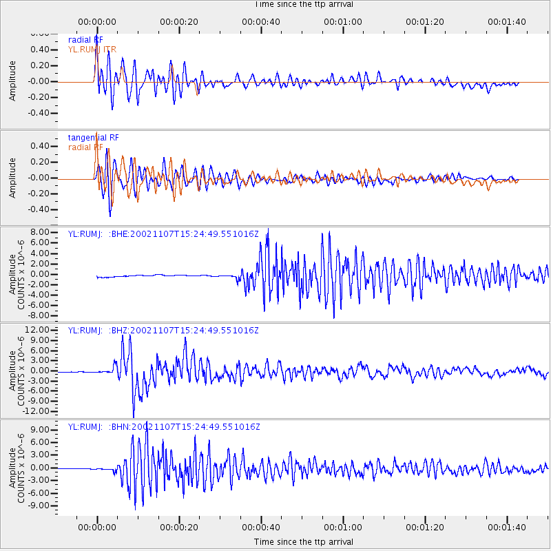
Earthquake location: Rat Islands, Aleutian Islands
Earthquake latitude/longitude: 51.2/179.3
Earthquake time(UTC): 2002/11/07 (311) 15:14:06 GMT
Earthquake Depth: 33 km
Earthquake Magnitude: 5.8 MB, 6.4 MS, 6.6 MW, 6.5 MW
Earthquake Catalog/Contributor: WHDF/NEIC
Network: YL Himalayan Nepal Tibet Experiment
Station: RUMJ YL.RUMJ
Lat/Lon: 27.30 N/86.55 E
Elevation: 1319 m
Distance: 70.9 deg
Az: 289.841 deg
Baz: 41.692 deg
Ray Param: 0.05463537
Estimated Moho Depth: 38.25 km
Estimated Crust Vp/Vs: 2.06
Assumed Crust Vp: 6.236 km/s
Estimated Crust Vs: 3.034 km/s
Estimated Crust Poisson's Ratio: 0.34
Radial Match: 89.472984 %
Radial Bump: 400
Transverse Match: 92.57393 %
Transverse Bump: 400
SOD ConfigId: 16844
Insert Time: 2010-02-26 16:07:22.344 +0000
GWidth: 2.5
Max Bumps: 400
Tol: 0.001

Signal To Noise

ChannelStoNSTALTA
YL:RUMJ: :BHZ:20021107T15:24:49.551016Z14.3285621.1410157E-67.963225E-8
YL:RUMJ: :BHN:20021107T15:24:49.551016Z2.22763923.2788805E-71.4719082E-7
YL:RUMJ: :BHE:20021107T15:24:49.551016Z2.61335094.182179E-71.6003129E-7
Arrivals
Ps6.7 SECOND
PpPs18 SECOND
PsPs/PpSs25 SECOND