You are here: Home > Network List > IW - Intermountain West Stations List
> Station MOOW Moose Ponds, Wyoming, USA > Earthquake Result Viewer
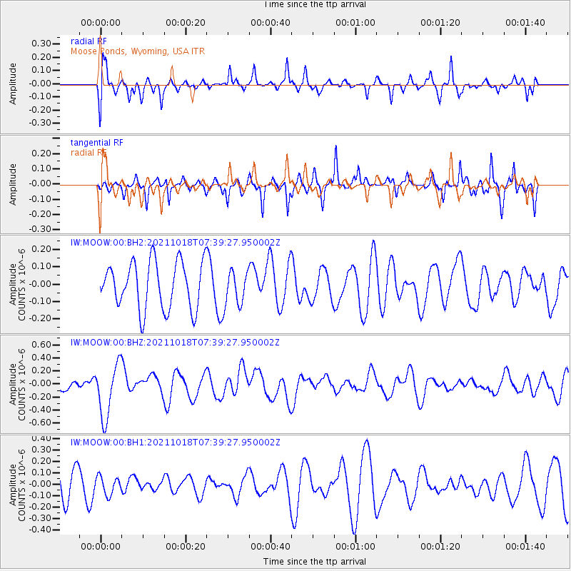
MOOW Moose Ponds, Wyoming, USA - Earthquake Result Viewer
*The percent match for this event was below the threshold and hence no stack was calculated.
| Earthquake location: |
Vanuatu Islands |
| Earthquake latitude/longitude: |
-13.7/166.9 |
| Earthquake time(UTC): |
2021/10/18 (291) 07:26:52 GMT |
| Earthquake Depth: |
96 km |
| Earthquake Magnitude: |
6.1 Mww |
| Earthquake Catalog/Contributor: |
NEIC PDE/us |
|
| Network: |
IW Intermountain West |
| Station: |
MOOW Moose Ponds, Wyoming, USA |
| Lat/Lon: |
43.75 N/110.74 W |
| Elevation: |
2128 m |
|
| Distance: |
93.9 deg |
| Az: |
46.044 deg |
| Baz: |
254.859 deg |
| Ray Param: |
$rayparam |
*The percent match for this event was below the threshold and hence was not used in the summary stack. |
|
| Radial Match: |
54.178146 % |
| Radial Bump: |
373 |
| Transverse Match: |
65.90598 % |
| Transverse Bump: |
326 |
| SOD ConfigId: |
26497111 |
| Insert Time: |
2021-11-01 07:40:05.320 +0000 |
| GWidth: |
2.5 |
| Max Bumps: |
400 |
| Tol: |
0.001 |
|
Signal To Noise
| Channel | StoN | STA | LTA |
| IW:MOOW:00:BHZ:20211018T07:39:27.950002Z | 3.6809688 | 4.256715E-7 | 1.1564116E-7 |
| IW:MOOW:00:BH1:20211018T07:39:27.950002Z | 0.77157634 | 8.003383E-8 | 1.03727686E-7 |
| IW:MOOW:00:BH2:20211018T07:39:27.950002Z | 0.69855934 | 9.5136976E-8 | 1.3619025E-7 |
| Arrivals |
| Ps | |
| PpPs | |
| PsPs/PpSs | |


