You are here: Home > Network List > UU - University of Utah Regional Network Stations List
> Station FORU South Mineral Mountains, UT, USA > Earthquake Result Viewer
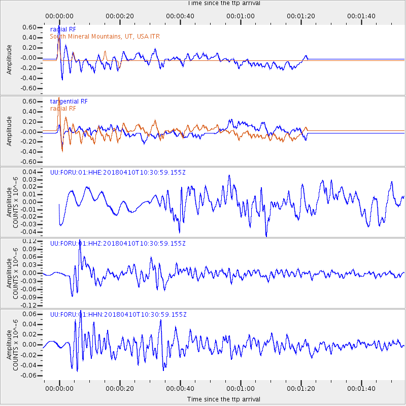
FORU South Mineral Mountains, UT, USA - Earthquake Result Viewer
*The percent match for this event was below the threshold and hence no stack was calculated.
| Earthquake location: |
Near Coast Of Central Chile |
| Earthquake latitude/longitude: |
-31.0/-71.6 |
| Earthquake time(UTC): |
2018/04/10 (100) 10:19:34 GMT |
| Earthquake Depth: |
76 km |
| Earthquake Magnitude: |
6.2 Mww |
| Earthquake Catalog/Contributor: |
NEIC PDE/us |
|
| Network: |
UU University of Utah Regional Network |
| Station: |
FORU South Mineral Mountains, UT, USA |
| Lat/Lon: |
38.46 N/112.86 W |
| Elevation: |
1840 m |
|
| Distance: |
79.1 deg |
| Az: |
328.147 deg |
| Baz: |
144.739 deg |
| Ray Param: |
$rayparam |
*The percent match for this event was below the threshold and hence was not used in the summary stack. |
|
| Radial Match: |
72.581375 % |
| Radial Bump: |
400 |
| Transverse Match: |
53.099392 % |
| Transverse Bump: |
400 |
| SOD ConfigId: |
2653092 |
| Insert Time: |
2018-04-24 10:27:38.034 +0000 |
| GWidth: |
2.5 |
| Max Bumps: |
400 |
| Tol: |
0.001 |
|
Signal To Noise
| Channel | StoN | STA | LTA |
| UU:FORU:01:HHZ:20180410T10:30:59.155Z | 7.91714 | 2.9003472E-8 | 3.6633772E-9 |
| UU:FORU:01:HHN:20180410T10:30:59.155Z | 1.9103355 | 1.3754898E-8 | 7.2002524E-9 |
| UU:FORU:01:HHE:20180410T10:30:59.155Z | 0.45284852 | 5.686963E-9 | 1.2558201E-8 |
| Arrivals |
| Ps | |
| PpPs | |
| PsPs/PpSs | |


