You are here: Home > Network List > US - United States National Seismic Network Stations List
> Station DUG Dugway, Tooele County, Utah, USA > Earthquake Result Viewer
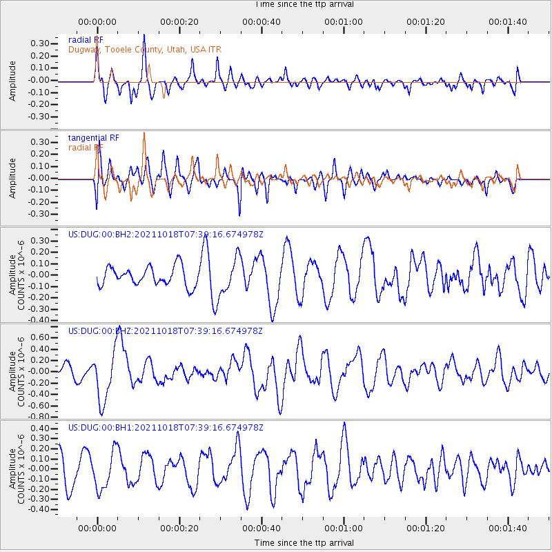
DUG Dugway, Tooele County, Utah, USA - Earthquake Result Viewer
*The percent match for this event was below the threshold and hence no stack was calculated.
| Earthquake location: |
Vanuatu Islands |
| Earthquake latitude/longitude: |
-13.7/166.9 |
| Earthquake time(UTC): |
2021/10/18 (291) 07:26:52 GMT |
| Earthquake Depth: |
96 km |
| Earthquake Magnitude: |
6.1 Mww |
| Earthquake Catalog/Contributor: |
NEIC PDE/us |
|
| Network: |
US United States National Seismic Network |
| Station: |
DUG Dugway, Tooele County, Utah, USA |
| Lat/Lon: |
40.19 N/112.81 W |
| Elevation: |
1477 m |
|
| Distance: |
91.5 deg |
| Az: |
49.039 deg |
| Baz: |
253.339 deg |
| Ray Param: |
$rayparam |
*The percent match for this event was below the threshold and hence was not used in the summary stack. |
|
| Radial Match: |
53.84793 % |
| Radial Bump: |
400 |
| Transverse Match: |
58.369278 % |
| Transverse Bump: |
400 |
| SOD ConfigId: |
26497111 |
| Insert Time: |
2021-11-01 07:44:47.223 +0000 |
| GWidth: |
2.5 |
| Max Bumps: |
400 |
| Tol: |
0.001 |
|
Signal To Noise
| Channel | StoN | STA | LTA |
| US:DUG:00:BHZ:20211018T07:39:16.674978Z | 6.129229 | 4.5544655E-7 | 7.4307316E-8 |
| US:DUG:00:BH1:20211018T07:39:16.674978Z | 1.2605981 | 1.9233313E-7 | 1.5257291E-7 |
| US:DUG:00:BH2:20211018T07:39:16.674978Z | 2.02315 | 1.656385E-7 | 8.187159E-8 |
| Arrivals |
| Ps | |
| PpPs | |
| PsPs/PpSs | |


