You are here: Home > Network List > US - United States National Seismic Network Stations List
> Station MNTX Cornudas Mountains, Texas, USA > Earthquake Result Viewer
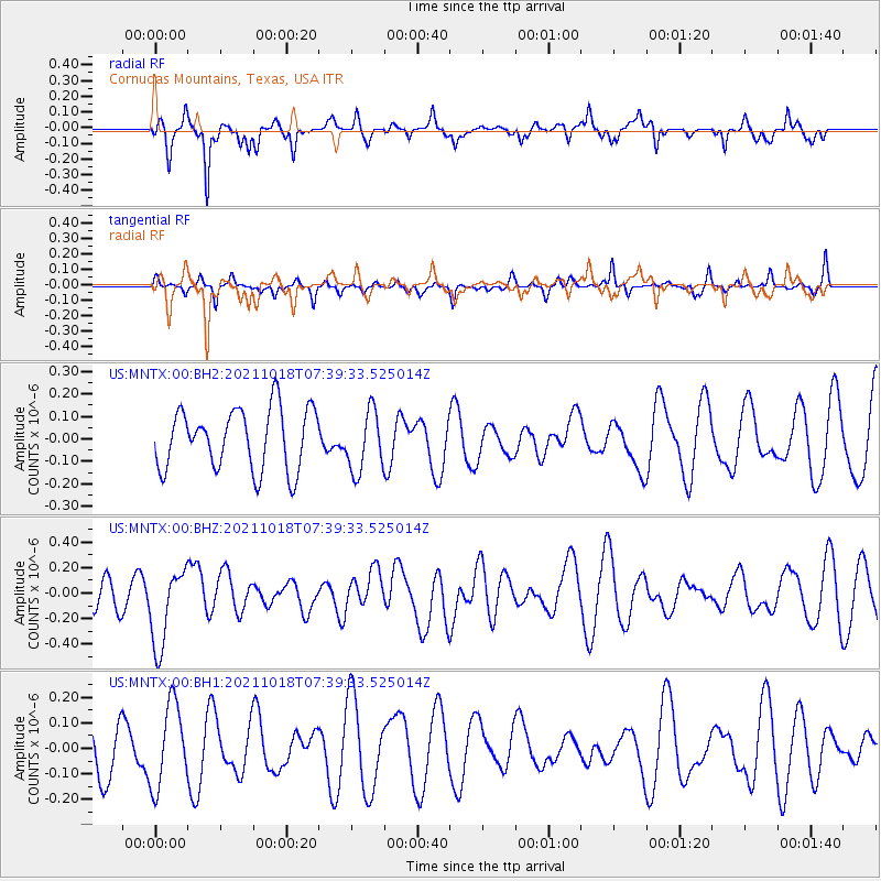
MNTX Cornudas Mountains, Texas, USA - Earthquake Result Viewer
*The percent match for this event was below the threshold and hence no stack was calculated.
| Earthquake location: |
Vanuatu Islands |
| Earthquake latitude/longitude: |
-13.7/166.9 |
| Earthquake time(UTC): |
2021/10/18 (291) 07:26:52 GMT |
| Earthquake Depth: |
96 km |
| Earthquake Magnitude: |
6.1 Mww |
| Earthquake Catalog/Contributor: |
NEIC PDE/us |
|
| Network: |
US United States National Seismic Network |
| Station: |
MNTX Cornudas Mountains, Texas, USA |
| Lat/Lon: |
31.70 N/105.38 W |
| Elevation: |
405 m |
|
| Distance: |
95.2 deg |
| Az: |
58.777 deg |
| Baz: |
257.135 deg |
| Ray Param: |
$rayparam |
*The percent match for this event was below the threshold and hence was not used in the summary stack. |
|
| Radial Match: |
74.900475 % |
| Radial Bump: |
313 |
| Transverse Match: |
35.427715 % |
| Transverse Bump: |
176 |
| SOD ConfigId: |
26497111 |
| Insert Time: |
2021-11-01 07:44:56.477 +0000 |
| GWidth: |
2.5 |
| Max Bumps: |
400 |
| Tol: |
0.001 |
|
Signal To Noise
| Channel | StoN | STA | LTA |
| US:MNTX:00:BHZ:20211018T07:39:33.525014Z | 3.271597 | 3.0799882E-7 | 9.414327E-8 |
| US:MNTX:00:BH1:20211018T07:39:33.525014Z | 1.5149231 | 1.623212E-7 | 1.07148146E-7 |
| US:MNTX:00:BH2:20211018T07:39:33.525014Z | 1.0088927 | 1.3657485E-7 | 1.3537104E-7 |
| Arrivals |
| Ps | |
| PpPs | |
| PsPs/PpSs | |


