You are here: Home > Network List > NK - Nepal Kathmandu (NK) Stations List
> Station KKN Kakani, Nepal > Earthquake Result Viewer
KKN Kakani, Nepal - Earthquake Result Viewer
| Earthquake location: |
Eastern Mediterranean Sea |
| Earthquake latitude/longitude: |
34.6/28.4 |
| Earthquake time(UTC): |
2021/10/19 (292) 05:32:32 GMT |
| Earthquake Depth: |
42 km |
| Earthquake Magnitude: |
5.9 mww |
| Earthquake Catalog/Contributor: |
NEIC PDE/us |
|
| Network: |
NK Nepal Kathmandu (NK) |
| Station: |
KKN Kakani, Nepal |
| Lat/Lon: |
27.80 N/85.28 E |
| Elevation: |
2042 m |
|
| Distance: |
48.6 deg |
| Az: |
81.619 deg |
| Baz: |
292.872 deg |
| Ray Param: |
0.069166414 |
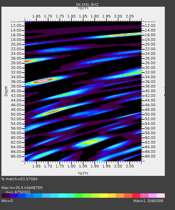
| Estimated Moho Depth: |
35.5 km |
| Estimated Crust Vp/Vs: |
1.68 |
| Assumed Crust Vp: |
6.142 km/s |
| Estimated Crust Vs: |
3.667 km/s |
| Estimated Crust Poisson's Ratio: |
0.22 |
|
| Radial Match: |
83.57064 % |
| Radial Bump: |
400 |
| Transverse Match: |
72.37595 % |
| Transverse Bump: |
400 |
| SOD ConfigId: |
26497111 |
| Insert Time: |
2021-11-02 05:44:41.196 +0000 |
| GWidth: |
2.5 |
| Max Bumps: |
400 |
| Tol: |
0.001 |
|

Signal To Noise
| Channel | StoN | STA | LTA |
| NK:KKN: :BHZ:20211019T05:40:41.559998Z | 19.879236 | 1.7918104E-6 | 9.013477E-8 |
| NK:KKN: :BHN:20211019T05:40:41.559998Z | 8.172286 | 6.475116E-7 | 7.923262E-8 |
| NK:KKN: :BHE:20211019T05:40:41.559998Z | 13.614629 | 9.103959E-7 | 6.686894E-8 |
| Arrivals |
| Ps | 4.1 SECOND |
| PpPs | 15 SECOND |
| PsPs/PpSs | 19 SECOND |


