You are here: Home > Network List > CU - Caribbean Network (USGS) Stations List
> Station GTBY Guantanamo Bay, Cuba > Earthquake Result Viewer
GTBY Guantanamo Bay, Cuba - Earthquake Result Viewer
| Earthquake location: |
Sea Of Okhotsk |
| Earthquake latitude/longitude: |
53.9/152.9 |
| Earthquake time(UTC): |
2008/07/05 (187) 02:12:04 GMT |
| Earthquake Depth: |
633 km |
| Earthquake Magnitude: |
6.8 MB, 7.7 MW, 7.7 MW |
| Earthquake Catalog/Contributor: |
WHDF/NEIC |
|
| Network: |
CU Caribbean Network (USGS) |
| Station: |
GTBY Guantanamo Bay, Cuba |
| Lat/Lon: |
19.93 N/75.11 W |
| Elevation: |
79 m |
|
| Distance: |
95.7 deg |
| Az: |
44.641 deg |
| Baz: |
333.759 deg |
| Ray Param: |
0.040006578 |
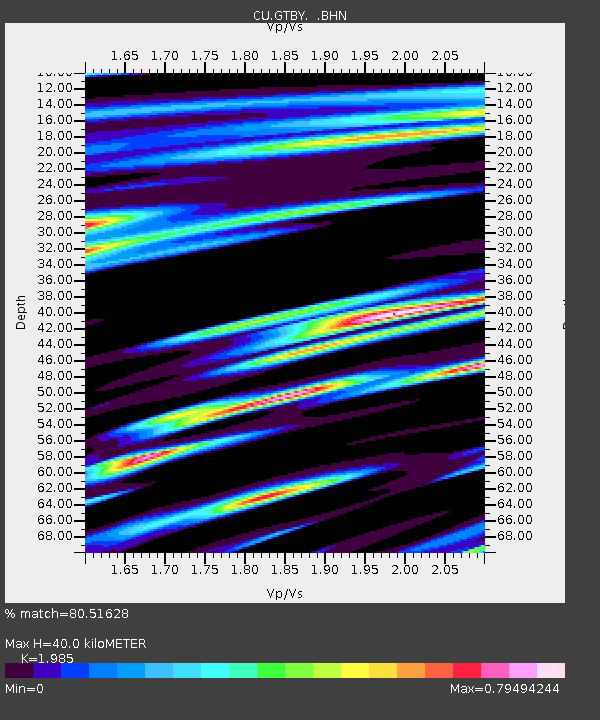
| Estimated Moho Depth: |
40.0 km |
| Estimated Crust Vp/Vs: |
1.99 |
| Assumed Crust Vp: |
6.048 km/s |
| Estimated Crust Vs: |
3.047 km/s |
| Estimated Crust Poisson's Ratio: |
0.33 |
|
| Radial Match: |
80.51628 % |
| Radial Bump: |
400 |
| Transverse Match: |
73.32633 % |
| Transverse Bump: |
400 |
| SOD ConfigId: |
2504 |
| Insert Time: |
2010-03-09 13:49:28.904 +0000 |
| GWidth: |
2.5 |
| Max Bumps: |
400 |
| Tol: |
0.001 |
|

Signal To Noise
| Channel | StoN | STA | LTA |
| CU:GTBY: :BHN:20080705T02:23:52.800007Z | 4.3649783 | 1.9021332E-6 | 4.357715E-7 |
| CU:GTBY: :BHE:20080705T02:23:52.800007Z | 2.0019386 | 6.2114975E-7 | 3.1027412E-7 |
| CU:GTBY: :BHZ:20080705T02:23:52.800007Z | 1.2653613 | 3.358341E-7 | 2.654057E-7 |
| Arrivals |
| Ps | 6.6 SECOND |
| PpPs | 19 SECOND |
| PsPs/PpSs | 26 SECOND |


