You are here: Home > Network List > US - United States National Seismic Network Stations List
> Station HDIL Hopedale, Illinois, USA > Earthquake Result Viewer
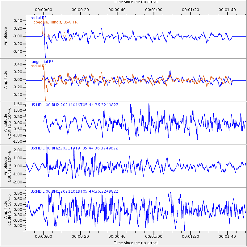
HDIL Hopedale, Illinois, USA - Earthquake Result Viewer
*The percent match for this event was below the threshold and hence no stack was calculated.
| Earthquake location: |
Eastern Mediterranean Sea |
| Earthquake latitude/longitude: |
34.6/28.4 |
| Earthquake time(UTC): |
2021/10/19 (292) 05:32:32 GMT |
| Earthquake Depth: |
42 km |
| Earthquake Magnitude: |
5.9 mww |
| Earthquake Catalog/Contributor: |
NEIC PDE/us |
|
| Network: |
US United States National Seismic Network |
| Station: |
HDIL Hopedale, Illinois, USA |
| Lat/Lon: |
40.56 N/89.29 W |
| Elevation: |
219 m |
|
| Distance: |
85.8 deg |
| Az: |
317.424 deg |
| Baz: |
47.105 deg |
| Ray Param: |
$rayparam |
*The percent match for this event was below the threshold and hence was not used in the summary stack. |
|
| Radial Match: |
67.91071 % |
| Radial Bump: |
400 |
| Transverse Match: |
45.366913 % |
| Transverse Bump: |
400 |
| SOD ConfigId: |
26497111 |
| Insert Time: |
2021-11-02 05:48:45.269 +0000 |
| GWidth: |
2.5 |
| Max Bumps: |
400 |
| Tol: |
0.001 |
|
Signal To Noise
| Channel | StoN | STA | LTA |
| US:HDIL:00:BHZ:20211019T05:44:36.324982Z | 2.5871093 | 6.968587E-7 | 2.6935803E-7 |
| US:HDIL:00:BH1:20211019T05:44:36.324982Z | 1.8548847 | 5.5070007E-7 | 2.9689178E-7 |
| US:HDIL:00:BH2:20211019T05:44:36.324982Z | 1.2861494 | 4.803624E-7 | 3.734888E-7 |
| Arrivals |
| Ps | |
| PpPs | |
| PsPs/PpSs | |


