You are here: Home > Network List > CI - Caltech Regional Seismic Network Stations List
> Station MUR Murrieta > Earthquake Result Viewer
MUR Murrieta - Earthquake Result Viewer
*The percent match for this event was below the threshold and hence no stack was calculated.
| Earthquake location: |
Tonga Islands |
| Earthquake latitude/longitude: |
-21.2/-175.8 |
| Earthquake time(UTC): |
2021/10/19 (292) 10:28:45 GMT |
| Earthquake Depth: |
10 km |
| Earthquake Magnitude: |
5.6 Mww |
| Earthquake Catalog/Contributor: |
NEIC PDE/us |
|
| Network: |
CI Caltech Regional Seismic Network |
| Station: |
MUR Murrieta |
| Lat/Lon: |
33.60 N/117.20 W |
| Elevation: |
562 m |
|
| Distance: |
78.0 deg |
| Az: |
46.728 deg |
| Baz: |
234.469 deg |
| Ray Param: |
$rayparam |
*The percent match for this event was below the threshold and hence was not used in the summary stack. |
|
| Radial Match: |
61.597923 % |
| Radial Bump: |
353 |
| Transverse Match: |
38.61742 % |
| Transverse Bump: |
400 |
| SOD ConfigId: |
26497111 |
| Insert Time: |
2021-11-02 10:35:17.378 +0000 |
| GWidth: |
2.5 |
| Max Bumps: |
400 |
| Tol: |
0.001 |
|
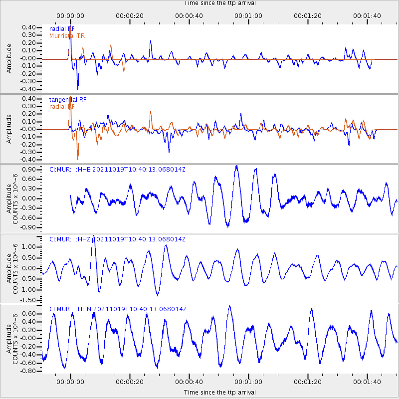
Signal To Noise
| Channel | StoN | STA | LTA |
| CI:MUR: :HHZ:20211019T10:40:13.068014Z | 1.622765 | 2.9862042E-7 | 1.840195E-7 |
| CI:MUR: :HHN:20211019T10:40:13.068014Z | 1.3455771 | 4.3330996E-7 | 3.2202536E-7 |
| CI:MUR: :HHE:20211019T10:40:13.068014Z | 1.1695098 | 2.3655684E-7 | 2.0227009E-7 |
| Arrivals |
| Ps | |
| PpPs | |
| PsPs/PpSs | |


