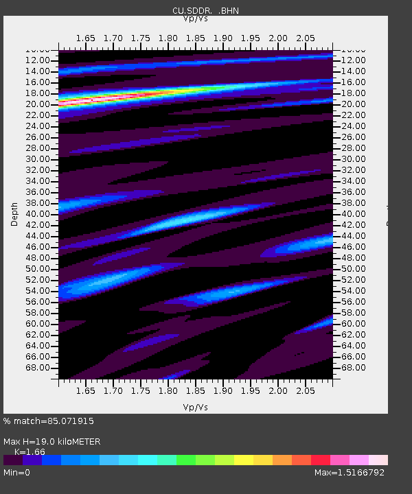
SDDR Presa de Sabaneta, Dominican Republic - Earthquake Result Viewer

Earthquake location: Andreanof Islands, Aleutian Is.
Earthquake latitude/longitude: 51.9/-177.5
Earthquake time(UTC): 2008/05/02 (123) 01:33:37 GMT
Earthquake Depth: 14 km
Earthquake Magnitude: 6.3 MB, 6.8 MS, 6.6 MW, 6.6 MW
Earthquake Catalog/Contributor: WHDF/NEIC
Network: CU Caribbean Network (USGS)
Station: SDDR Presa de Sabaneta, Dominican Republic
Lat/Lon: 18.98 N/71.29 W
Elevation: 589 m
Distance: 84.9 deg
Az: 65.81 deg
Baz: 323.291 deg
Ray Param: 0.045171164
Estimated Moho Depth: 19.0 km
Estimated Crust Vp/Vs: 1.66
Assumed Crust Vp: 6.448 km/s
Estimated Crust Vs: 3.884 km/s
Estimated Crust Poisson's Ratio: 0.22
Radial Match: 85.071915 %
Radial Bump: 400
Transverse Match: 75.522995 %
Transverse Bump: 400
SOD ConfigId: 2504
Insert Time: 2010-03-09 13:50:51.499 +0000
GWidth: 2.5
Max Bumps: 400
Tol: 0.001

Signal To Noise

ChannelStoNSTALTA
CU:SDDR: :BHN:20080502T01:45:39.87501Z3.20819693.6479372E-71.13706776E-7
CU:SDDR: :BHE:20080502T01:45:39.87501Z1.17275731.1816252E-71.00756154E-7
CU:SDDR: :BHZ:20080502T01:45:39.87501Z0.942527231.16744765E-71.2386354E-7
Arrivals
Ps2.0 SECOND
PpPs7.6 SECOND
PsPs/PpSs9.6 SECOND