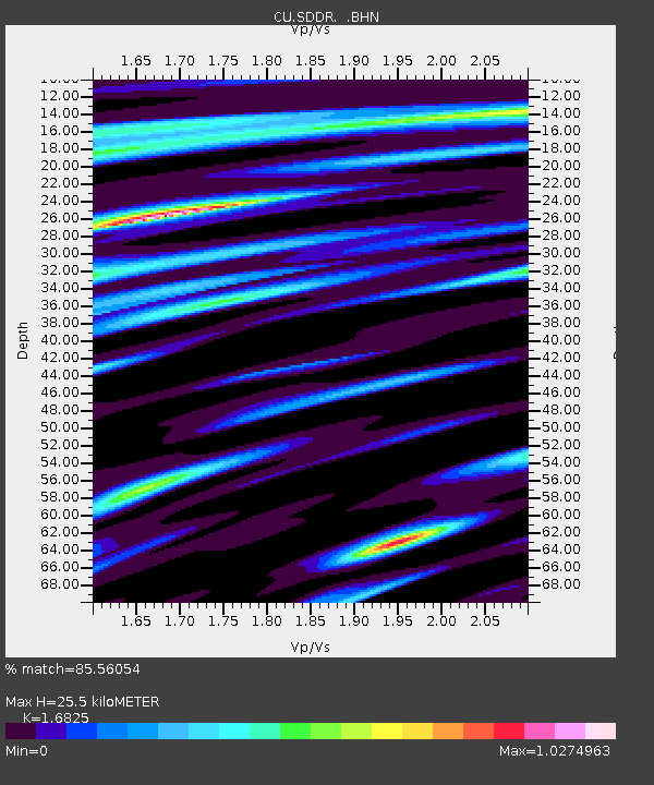
SDDR Presa de Sabaneta, Dominican Republic - Earthquake Result Viewer

Earthquake location: Central Mid-Atlantic Ridge
Earthquake latitude/longitude: 0.7/-30.3
Earthquake time(UTC): 2007/07/03 (184) 08:26:00 GMT
Earthquake Depth: 10 km
Earthquake Magnitude: 5.8 MB, 5.9 MS, 6.3 MW, 6.1 MW
Earthquake Catalog/Contributor: WHDF/NEIC
Network: CU Caribbean Network (USGS)
Station: SDDR Presa de Sabaneta, Dominican Republic
Lat/Lon: 18.98 N/71.29 W
Elevation: 589 m
Distance: 44.1 deg
Az: 296.855 deg
Baz: 109.487 deg
Ray Param: 0.07211589
Estimated Moho Depth: 25.5 km
Estimated Crust Vp/Vs: 1.68
Assumed Crust Vp: 6.448 km/s
Estimated Crust Vs: 3.832 km/s
Estimated Crust Poisson's Ratio: 0.23
Radial Match: 85.56054 %
Radial Bump: 400
Transverse Match: 68.392746 %
Transverse Bump: 400
SOD ConfigId: 2564
Insert Time: 2010-03-09 13:50:56.143 +0000
GWidth: 2.5
Max Bumps: 400
Tol: 0.001

Signal To Noise

ChannelStoNSTALTA
CU:SDDR: :BHN:20070703T08:33:38.299014Z1.04434172.060192E-71.9727182E-7
CU:SDDR: :BHE:20070703T08:33:38.299014Z1.31623952.1866603E-71.6612935E-7
CU:SDDR: :BHZ:20070703T08:33:38.299014Z4.6996944.2635892E-79.072057E-8
Arrivals
Ps2.9 SECOND
PpPs9.9 SECOND
PsPs/PpSs13 SECOND