You are here: Home > Network List > AV - Alaska Volcano Observatory Stations List
> Station AMKA Regional Station, Amchitka Island, Alaska > Earthquake Result Viewer
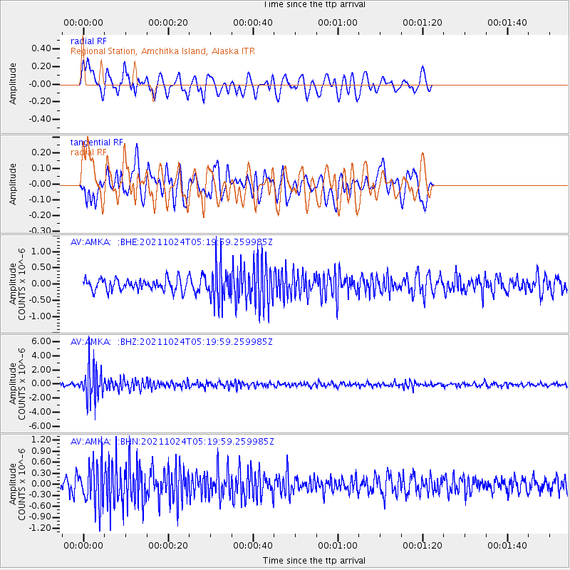
AMKA Regional Station, Amchitka Island, Alaska - Earthquake Result Viewer
*The percent match for this event was below the threshold and hence no stack was calculated.
| Earthquake location: |
Taiwan |
| Earthquake latitude/longitude: |
24.6/121.8 |
| Earthquake time(UTC): |
2021/10/24 (297) 05:11:34 GMT |
| Earthquake Depth: |
65 km |
| Earthquake Magnitude: |
6.2 mww |
| Earthquake Catalog/Contributor: |
NEIC PDE/us |
|
| Network: |
AV Alaska Volcano Observatory |
| Station: |
AMKA Regional Station, Amchitka Island, Alaska |
| Lat/Lon: |
51.38 N/179.30 E |
| Elevation: |
116 m |
|
| Distance: |
51.0 deg |
| Az: |
42.825 deg |
| Baz: |
260.945 deg |
| Ray Param: |
$rayparam |
*The percent match for this event was below the threshold and hence was not used in the summary stack. |
|
| Radial Match: |
59.55477 % |
| Radial Bump: |
400 |
| Transverse Match: |
56.004353 % |
| Transverse Bump: |
400 |
| SOD ConfigId: |
26497111 |
| Insert Time: |
2021-11-07 05:17:19.711 +0000 |
| GWidth: |
2.5 |
| Max Bumps: |
400 |
| Tol: |
0.001 |
|
Signal To Noise
| Channel | StoN | STA | LTA |
| AV:AMKA: :BHZ:20211024T05:19:59.259985Z | 11.023048 | 2.2570305E-6 | 2.0475555E-7 |
| AV:AMKA: :BHN:20211024T05:19:59.259985Z | 3.5442243 | 5.484494E-7 | 1.5474454E-7 |
| AV:AMKA: :BHE:20211024T05:19:59.259985Z | 3.046301 | 5.342522E-7 | 1.7537735E-7 |
| Arrivals |
| Ps | |
| PpPs | |
| PsPs/PpSs | |


