You are here: Home > Network List > CU - Caribbean Network (USGS) Stations List
> Station TGUH Tegucigalpa, Honduras > Earthquake Result Viewer
TGUH Tegucigalpa, Honduras - Earthquake Result Viewer
| Earthquake location: |
Andreanof Islands, Aleutian Is. |
| Earthquake latitude/longitude: |
52.2/-178.7 |
| Earthquake time(UTC): |
2008/03/22 (082) 21:24:11 GMT |
| Earthquake Depth: |
132 km |
| Earthquake Magnitude: |
5.8 MB, 6.2 MW, 6.1 MW |
| Earthquake Catalog/Contributor: |
WHDF/NEIC |
|
| Network: |
CU Caribbean Network (USGS) |
| Station: |
TGUH Tegucigalpa, Honduras |
| Lat/Lon: |
14.06 N/87.27 W |
| Elevation: |
0.0 m |
|
| Distance: |
79.9 deg |
| Az: |
80.182 deg |
| Baz: |
321.298 deg |
| Ray Param: |
0.048326205 |
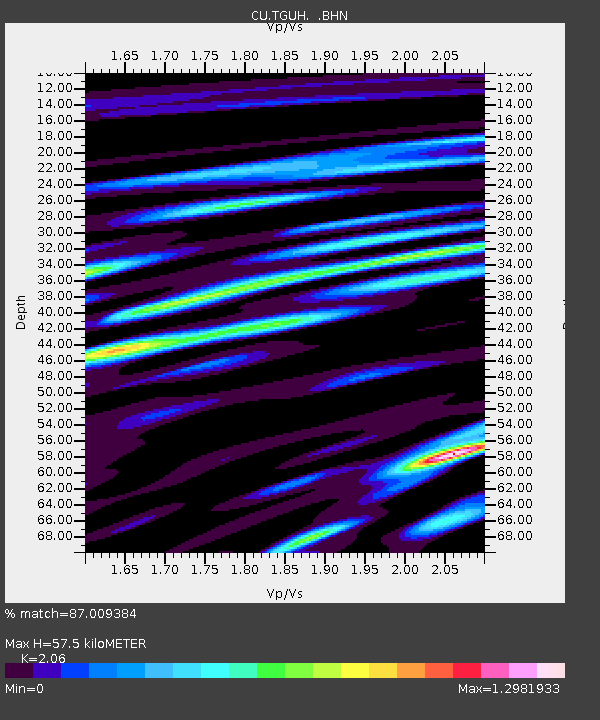
| Estimated Moho Depth: |
57.5 km |
| Estimated Crust Vp/Vs: |
2.06 |
| Assumed Crust Vp: |
6.597 km/s |
| Estimated Crust Vs: |
3.203 km/s |
| Estimated Crust Poisson's Ratio: |
0.35 |
|
| Radial Match: |
87.009384 % |
| Radial Bump: |
400 |
| Transverse Match: |
81.96025 % |
| Transverse Bump: |
400 |
| SOD ConfigId: |
2504 |
| Insert Time: |
2010-03-09 13:51:50.313 +0000 |
| GWidth: |
2.5 |
| Max Bumps: |
400 |
| Tol: |
0.001 |
|

Signal To Noise
| Channel | StoN | STA | LTA |
| CU:TGUH: :BHN:20080322T21:35:34.449016Z | 18.87093 | 2.2005986E-6 | 1.16613144E-7 |
| CU:TGUH: :BHE:20080322T21:35:34.449016Z | 3.2325988 | 4.780177E-7 | 1.4787412E-7 |
| CU:TGUH: :BHZ:20080322T21:35:34.449016Z | 3.528824 | 6.381882E-7 | 1.8085011E-7 |
| Arrivals |
| Ps | 9.5 SECOND |
| PpPs | 26 SECOND |
| PsPs/PpSs | 35 SECOND |


