You are here: Home > Network List > CU - Caribbean Network (USGS) Stations List
> Station TGUH Tegucigalpa, Honduras > Earthquake Result Viewer
TGUH Tegucigalpa, Honduras - Earthquake Result Viewer
| Earthquake location: |
Jujuy Province, Argentina |
| Earthquake latitude/longitude: |
-22.2/-65.8 |
| Earthquake time(UTC): |
2007/07/21 (202) 15:34:52 GMT |
| Earthquake Depth: |
290 km |
| Earthquake Magnitude: |
5.8 MB, 6.4 MW, 6.3 MW |
| Earthquake Catalog/Contributor: |
WHDF/NEIC |
|
| Network: |
CU Caribbean Network (USGS) |
| Station: |
TGUH Tegucigalpa, Honduras |
| Lat/Lon: |
14.06 N/87.27 W |
| Elevation: |
0.0 m |
|
| Distance: |
41.7 deg |
| Az: |
327.688 deg |
| Baz: |
149.293 deg |
| Ray Param: |
0.07242602 |
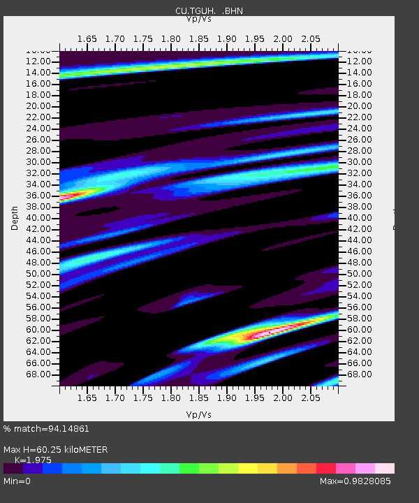
| Estimated Moho Depth: |
60.25 km |
| Estimated Crust Vp/Vs: |
1.98 |
| Assumed Crust Vp: |
6.597 km/s |
| Estimated Crust Vs: |
3.341 km/s |
| Estimated Crust Poisson's Ratio: |
0.33 |
|
| Radial Match: |
94.14861 % |
| Radial Bump: |
400 |
| Transverse Match: |
79.72252 % |
| Transverse Bump: |
400 |
| SOD ConfigId: |
2564 |
| Insert Time: |
2010-03-09 13:52:08.544 +0000 |
| GWidth: |
2.5 |
| Max Bumps: |
400 |
| Tol: |
0.001 |
|

Signal To Noise
| Channel | StoN | STA | LTA |
| CU:TGUH: :BHN:20070721T15:41:43.050012Z | 6.3047357 | 5.929909E-7 | 9.405484E-8 |
| CU:TGUH: :BHE:20070721T15:41:43.050012Z | 3.4050472 | 2.9876134E-7 | 8.774074E-8 |
| CU:TGUH: :BHZ:20070721T15:41:43.050012Z | 10.185198 | 1.2004753E-6 | 1.1786469E-7 |
| Arrivals |
| Ps | 9.5 SECOND |
| PpPs | 26 SECOND |
| PsPs/PpSs | 35 SECOND |


