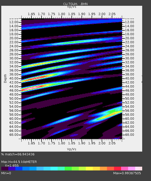
TGUH Tegucigalpa, Honduras - Earthquake Result Viewer

Earthquake location: Fox Islands, Aleutian Islands
Earthquake latitude/longitude: 52.5/-168.0
Earthquake time(UTC): 2007/07/15 (196) 13:08:00 GMT
Earthquake Depth: 10 km
Earthquake Magnitude: 5.8 MB, 5.9 MS, 6.1 MW, 6.0 MW
Earthquake Catalog/Contributor: WHDF/NEIC
Network: CU Caribbean Network (USGS)
Station: TGUH Tegucigalpa, Honduras
Lat/Lon: 14.06 N/87.27 W
Elevation: 0.0 m
Distance: 73.4 deg
Az: 88.533 deg
Baz: 320.946 deg
Ray Param: 0.05304609
Estimated Moho Depth: 44.5 km
Estimated Crust Vp/Vs: 1.65
Assumed Crust Vp: 6.597 km/s
Estimated Crust Vs: 3.986 km/s
Estimated Crust Poisson's Ratio: 0.21
Radial Match: 86.943436 %
Radial Bump: 400
Transverse Match: 82.40224 %
Transverse Bump: 400
SOD ConfigId: 2564
Insert Time: 2010-03-09 13:52:10.209 +0000
GWidth: 2.5
Max Bumps: 400
Tol: 0.001

Signal To Noise

ChannelStoNSTALTA
CU:TGUH: :BHN:20070715T13:19:01.500002Z1.42164551.269384E-78.928978E-8
CU:TGUH: :BHE:20070715T13:19:01.500002Z1.30209881.5401946E-71.18285556E-7
CU:TGUH: :BHZ:20070715T13:19:01.500002Z4.48885974.950994E-71.1029513E-7
Arrivals
Ps4.6 SECOND
PpPs17 SECOND
PsPs/PpSs22 SECOND