You are here: Home > Network List > UW - Pacific Northwest Regional Seismic Network Stations List
> Station UMAT Pilot Rock, OR, USA > Earthquake Result Viewer
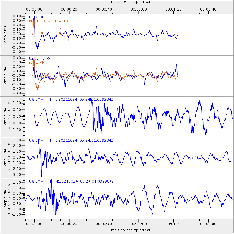
UMAT Pilot Rock, OR, USA - Earthquake Result Viewer
*The percent match for this event was below the threshold and hence no stack was calculated.
| Earthquake location: |
Taiwan |
| Earthquake latitude/longitude: |
24.6/121.8 |
| Earthquake time(UTC): |
2021/10/24 (297) 05:11:34 GMT |
| Earthquake Depth: |
65 km |
| Earthquake Magnitude: |
6.2 mww |
| Earthquake Catalog/Contributor: |
NEIC PDE/us |
|
| Network: |
UW Pacific Northwest Regional Seismic Network |
| Station: |
UMAT Pilot Rock, OR, USA |
| Lat/Lon: |
45.29 N/118.96 W |
| Elevation: |
1318 m |
|
| Distance: |
91.2 deg |
| Az: |
38.044 deg |
| Baz: |
307.356 deg |
| Ray Param: |
$rayparam |
*The percent match for this event was below the threshold and hence was not used in the summary stack. |
|
| Radial Match: |
58.450413 % |
| Radial Bump: |
400 |
| Transverse Match: |
60.558407 % |
| Transverse Bump: |
400 |
| SOD ConfigId: |
26497111 |
| Insert Time: |
2021-11-07 05:43:27.658 +0000 |
| GWidth: |
2.5 |
| Max Bumps: |
400 |
| Tol: |
0.001 |
|
Signal To Noise
| Channel | StoN | STA | LTA |
| UW:UMAT: :HHZ:20211024T05:24:01.039984Z | 3.984247 | 1.4488073E-6 | 3.6363392E-7 |
| UW:UMAT: :HHN:20211024T05:24:01.039984Z | 0.56698346 | 3.543533E-7 | 6.2498E-7 |
| UW:UMAT: :HHE:20211024T05:24:01.039984Z | 1.9050122 | 7.316385E-7 | 3.8405975E-7 |
| Arrivals |
| Ps | |
| PpPs | |
| PsPs/PpSs | |


