You are here: Home > Network List > AZ - ANZA Regional Network Stations List
> Station FRD AZ.FRD > Earthquake Result Viewer
FRD AZ.FRD - Earthquake Result Viewer
*The percent match for this event was below the threshold and hence no stack was calculated.
| Earthquake location: |
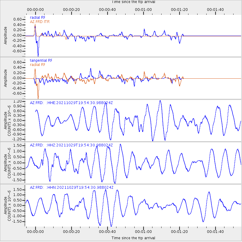
Kermadec Islands Region |
| Earthquake latitude/longitude: |
-29.4/-176.1 |
| Earthquake time(UTC): |
2021/10/29 (302) 19:42:31 GMT |
| Earthquake Depth: |
10 km |
| Earthquake Magnitude: |
5.5 mww |
| Earthquake Catalog/Contributor: |
NEIC PDE/us |
|
| Network: |
AZ ANZA Regional Network |
| Station: |
FRD AZ.FRD |
| Lat/Lon: |
33.49 N/116.60 W |
| Elevation: |
1164 m |
|
| Distance: |
84.2 deg |
| Az: |
46.362 deg |
| Baz: |
229.081 deg |
| Ray Param: |
$rayparam |
*The percent match for this event was below the threshold and hence was not used in the summary stack. |
|
| Radial Match: |
79.57674 % |
| Radial Bump: |
400 |
| Transverse Match: |
56.515484 % |
| Transverse Bump: |
400 |
| SOD ConfigId: |
26497111 |
| Insert Time: |
2021-11-12 19:47:04.393 +0000 |
| GWidth: |
2.5 |
| Max Bumps: |
400 |
| Tol: |
0.001 |
|
Signal To Noise
| Channel | StoN | STA | LTA |
| AZ:FRD: :HHZ:20211029T19:54:30.988024Z | 0.50961334 | 3.1313027E-7 | 6.144468E-7 |
| AZ:FRD: :HHN:20211029T19:54:30.988024Z | 1.0477276 | 5.622155E-7 | 5.366047E-7 |
| AZ:FRD: :HHE:20211029T19:54:30.988024Z | 1.663 | 6.1362863E-7 | 3.6898896E-7 |
| Arrivals |
| Ps | |
| PpPs | |
| PsPs/PpSs | |


